Cesium开发中,如果想要看到真实感,地形数据(DEM)不可或缺。
但是,地形数据只包含高程信息,只能看出高低起伏。所以,需要叠加其它的影像信息才能达到想要的效果。
cesium中有一个TerrainProvider函数可以加载地形图。。
var viewer = new Cesium.Viewer('cesiumContainer');

var terrainProvider = new Cesium.CesiumTerrainProvider({
    url: 'http://localhost:8081/wzf_dem'
    });
viewer.terrainProvider = terrainProvider;

viewer.camera.flyTo({
    destination:Cesium.Cartesian3.fromDegrees(116, 40, 15000.0)
});
参考:https://www.jianshu.com/p/44ed84b44e6c
Cesium地形系统
Cesium中的地形系统是一种由流式瓦片数据生成地形的技术。cesiumjs支持两种类型的地形,STK World Terrain和Small Terrain。
STK World Terrain是高分辨率,基于quantized mesh的地形。这是一种基于TIN三角网的地形,可充分利用GL中的Shader来渲染,效果相当逼真。STK World Terra使用了多种数据源,分别适应不同地区和不同精度时的情形。update:STK World Terrain has been depracated。
Small Terrain 是中等高分辨率,基于 heightmap 的地形,渲染出的地形效果不如 quantized mesh 的地形,但也基本能接受。网上已经有一些开源的生成工具可以由 DEM 数据生成这种规范的.terrain 文件,因此我们下面重点说明这种类型的地形生成。
gdal2srtmtiles程序.py使用教程
1. 安装Python2.7。
2. reg
3. PIL安装
4. gdal core安装
5. numpy安装
6. gdal for python安装
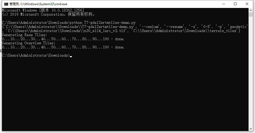
7. T7-gdal2srtmtiles-demo.py
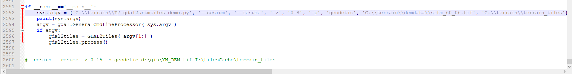
修改
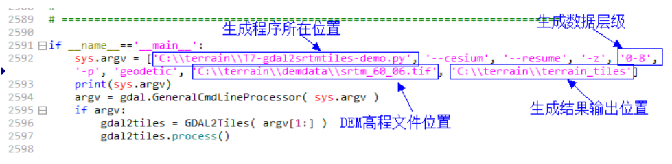
修改 T7-gdal2srtmtiles-demo.py 的位置为你机器上的位置,修改 tif 的位置和输出文件的位置。-z 后面可以输入生成的级数如 0-8 或 0-15 等,级数越大越慢。
修改完成后保存。
gdal2srtmtiles-demo.py完整程序:
#!/usr/bin/env python
#******************************************************************************
#  $Id: gdal2tiles.py 19288 2010-04-02 18:36:17Z rouault $
#
# Project:  Google Summer of Code 2007, 2008 (http://code.google.com/soc/)
# Support:  BRGM (http://www.brgm.fr)
# Purpose:  Convert a raster into TMS (Tile Map Service) tiles in a directory.
#           - generate Google Earth metadata (KML SuperOverlay)
#           - generate simple HTML viewer based on Google Maps and OpenLayers
#           - support of global tiles (Spherical Mercator) for compatibility
#               with interactive web maps a la Google Maps
# Author:   Klokan Petr Pridal, klokan at klokan dot cz
# Web:      http://www.klokan.cz/projects/gdal2tiles/
# GUI:      http://www.maptiler.org/
#
###############################################################################
# Copyright (c) 2008, Klokan Petr Pridal
#
#  Permission is hereby granted, free of charge, to any person obtaining a
#  copy of this software and associated documentation files (the "Software"),
#  to deal in the Software without restriction, including without limitation
#  the rights to use, copy, modify, merge, publish, distribute, sublicense,
#  and/or sell copies of the Software, and to permit persons to whom the
#  Software is furnished to do so, subject to the following conditions:
#
#  The above copyright notice and this permission notice shall be included
#  in all copies or substantial portions of the Software.
#
#  THE SOFTWARE IS PROVIDED "AS IS", WITHOUT WARRANTY OF ANY KIND, EXPRESS
#  OR IMPLIED, INCLUDING BUT NOT LIMITED TO THE WARRANTIES OF MERCHANTABILITY,
#  FITNESS FOR A PARTICULAR PURPOSE AND NONINFRINGEMENT. IN NO EVENT SHALL
#  THE AUTHORS OR COPYRIGHT HOLDERS BE LIABLE FOR ANY CLAIM, DAMAGES OR OTHER
#  LIABILITY, WHETHER IN AN ACTION OF CONTRACT, TORT OR OTHERWISE, ARISING
#  FROM, OUT OF OR IN CONNECTION WITH THE SOFTWARE OR THE USE OR OTHER
将上边的地形瓦片文件,发布到tomcat,IIS等服务器。发布完成后的访问地址为:http://localhost:8088/data/terrain_tiles
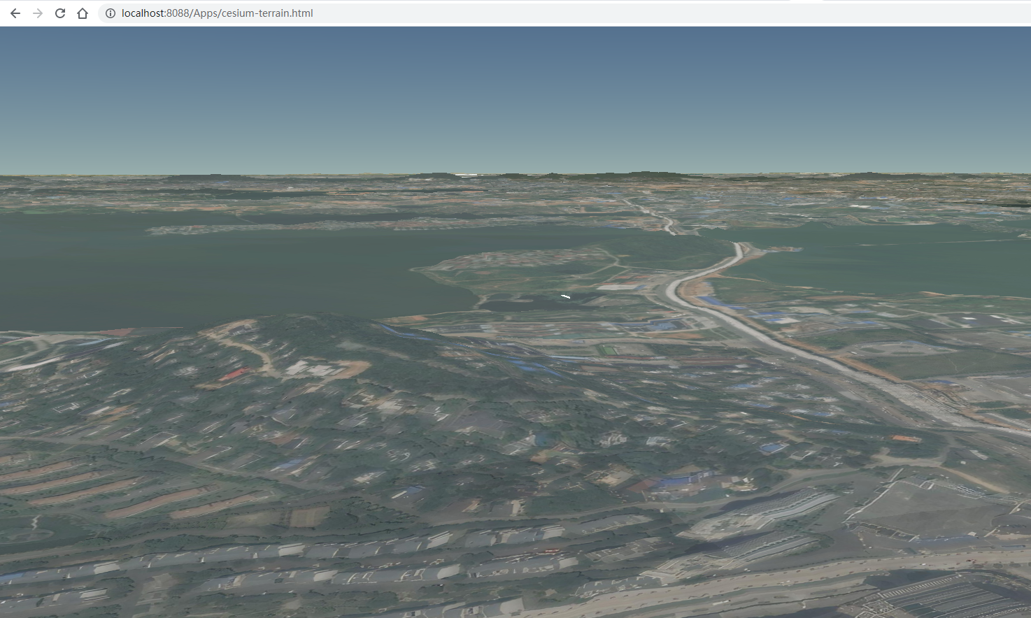
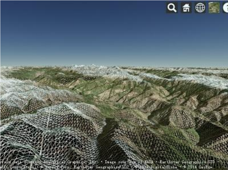
可以看到,有山的地方还是比较明显的。。其他地方就顶多是坑坑洼洼,没有太高的凸起

主要参考:https://www.jianshu.com/p/44ed84b44e6c