一 . 最近在弄智能调度系统,就需要在地图上实现模拟车辆的某一个时间段的运动轨迹。
百度地图已经有了这个Demo的示例。附上GPS-单点沿线运动Demo链接:http://developer.baidu.com/map/jsdemo.htm#c2_5
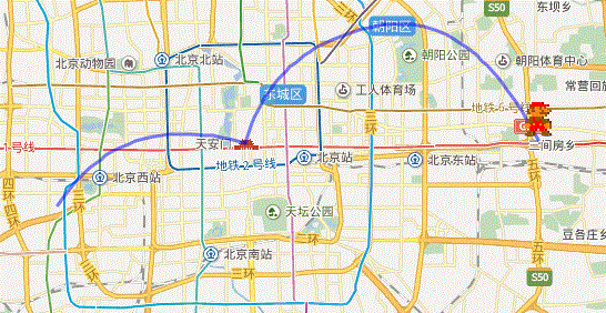
二 . 在这个Demo上进行改造的百度地图如下图所示:
百度地图实现代码如下:
<!DOCTYPE html>
<html>
<head>
    <meta http-equiv="Content-Type" content="text/html; charset=utf-8" />
    <meta name="viewport" content="initial-scale=1.0, user-scalable=no" />
    <style type="text/css">
        body, html,#allmap {width: 100%;height: 100%;overflow: hidden;margin:0;font-family:"微软雅黑";}
    </style>
    <script type="text/javascript" src="http://api.map.baidu.com/api?v=2.0&ak=TUaQdFgQ4GTsZjGGRCHWDCsx"></script>
    <script type="text/javascript" src="http://api.map.baidu.com/library/CurveLine/1.5/src/CurveLine.min.js"></script>
    <title>百度地图--单个标注点沿线的轨迹运动</title>
</head>
<body>
    <div id="allmap"></div>
</body>
</html>
<script type="text/javascript">
    // 百度地图API功能
    var curve;
    var map = new BMap.Map("allmap");
    map.centerAndZoom(new BMap.Point(116.403694,39.91582), 12);
    var myIcon = new BMap.Icon("http://developer.baidu.com/map/jsdemo/img/Mario.png", new BMap.Size(32, 70), {    //小车图片
        //offset: new BMap.Size(0, -5),    //相当于CSS精灵
        imageOffset: new BMap.Size(0, 0)    //图片的偏移量。为了是图片底部中心对准坐标点。
      });
    var points;
    var ps=[];
    ps.push(new BMap.Point(116.306533,39.890581));
    ps.push(new BMap.Point(116.403694,39.91582));
    ps.push(new BMap.Point(116.475558,39.962733));
    ps.push(new BMap.Point(116.555472,39.916706));
    ps.push(new BMap.Point(116.529025,39.869762));


    window.run = function (){
        var pts = ps;    //通过驾车实例,获得一系列点的数组
            var paths = pts.length;    //获得有几个点
            var carMk = new BMap.Marker(pts[0],{icon:myIcon});
            map.addOverlay(carMk);
            points = [pts[0],pts[1]];
                curve = new BMapLib.CurveLine(points, {strokeColor:"blue", strokeWeight:3, strokeOpacity:0.5}); //创建弧线对象
                map.addOverlay(curve); //添加到地图中
                carMk.setPosition(pts[1]);
            i=1;
            function resetMkPoint(i){
                points = [pts[i-1],pts[i]];
                curve = new BMapLib.CurveLine(points, {strokeColor:"blue", strokeWeight:3, strokeOpacity:0.5}); //创建弧线对象
                map.addOverlay(curve); //添加到地图中
                carMk.setPosition(pts[i]);
                if(i < paths){
                    setTimeout(function(){
                        i++;
                        resetMkPoint(i);
                    },500);
                }
            }
            setTimeout(function(){
                resetMkPoint(2);
            },500)
    }
    setTimeout(function(){
        run();
    },100);
</script>
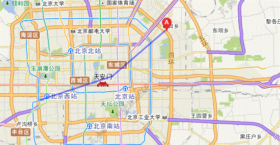
参考百度地图代码,使用天地图来模拟的页面效果。如下图所示:
天地图实现代码如下:
<!DOCTYPE html>
<html>
<head>
<meta name="keywords" content="天地图" charset="utf-8"/>
<title>天地图-地图API-范例-画线</title>
<script language="javascript" src="http://api.tianditu.com/js/maps.js"></script>
</head>
<body>
    <button type="button" onclick="goRun()">Click Me!</button>
    <br/>
    <div id="mapDiv" style="position:absolute;100%; height:90%"></div>
</body>
<script language="javascript">
    var map,zoom = 11,points,line;
    var myIcon = new TIcon("http://api.tianditu.com/img/map/markerA.png",new TSize(19,27),{anchor:new TPixel(9,27)});
    //初始化地图对象
    map=new TMap("mapDiv");
    //设置显示地图的中心点和级别
    map.centerAndZoom(new TLngLat(116.403694,39.91582),zoom);

    points = [];
    points.push(new TLngLat(116.306533,39.890581));
        points.push(new TLngLat(116.403694,39.91582));
        points.push(new TLngLat(116.475558,39.962733));
        points.push(new TLngLat(116.555472,39.916706));
    points.push(new TLngLat(116.529025,39.869762));

    function goRun(){
        var pts = points;    //通过驾车实例,获得一系列点的数组
            var paths = pts.length;    //获得有几个点
            var carMk = new TMarker(pts[0],{icon:myIcon});//地图添加自定义标识
            points = [pts[0],pts[1]];
            line = new TPolyline(points, {strokeColor:"blue", strokeWeight:3, strokeOpacity:0.5}); //创建线对象
            map.addOverLay(carMk);
            map.addOverLay(line); //添加到地图中
            carMk.setLngLat(pts[1]);
            function resetMkPoint(i){
                carMk.setLngLat(pts[i]);
                points = [pts[i-1],pts[i]];
                line = new TPolyline(points, {strokeColor:"blue", strokeWeight:3, strokeOpacity:0.5}); //创建线对象
                map.addOverLay(line); //添加到地图中
                if(i < paths){
                    setTimeout(function(){
                        i++;
                        resetMkPoint(i);
                    },500);
                }
            }
            setTimeout(function(){
                resetMkPoint(2);
            },500)

    }
</script>
</html>
三 . 总结。
天地图与百度地图的代码很相似,天地图的功能,基本可以通过百度地图代码来改造,虽然天地图示例Demo没有百度地图全面,但是通过百度地图对比来开发,基本的功能实现不难。