1. 这个不觉明历。在我看来,这和 boxs 那个例子差不多。
2. 只不过扩展类 TestBoxs 继承了 maptalks.MergedMixin ,这个估计要看源码才能明白是啥了。
  1  class TestBoxs extends maptalks.MergedMixin(maptalks.BaseObject) {
  2             constructor(points, options, material, layer) {
  3                 if (!Array.isArray(points)) {
  4                     points = [points];
  5                 }
  6                 const len = points.length;
  7                 const center = getCenterOfPoints(points);
  8                 const centerPt = layer.coordinateToVector3(center);
  9                 const geometries = [], bars = [], geometriesAttributes = [], faceMap = [];
 10                 let faceIndex = 0, psIndex = 0, normalIndex = 0, uvIndex = 0;
 11                 for (let i = 0; i < len; i++) {
 12                     const opts = maptalks.Util.extend({ index: i }, OPTIONS1, points[i]);
 13                     const { radius, altitude, topColor, bottomColor, height, coordinate } = opts;
 14                     const r = layer.distanceToVector3(radius, radius).x;
 15                     const h = layer.distanceToVector3(height, height).x;
 16                     const alt = layer.distanceToVector3(altitude, altitude).x;
 17                     const buffGeom = defaultGeometry.clone();
 18                     buffGeom.scale(r * 2, r * 2, h);
 19                     const v = layer.coordinateToVector3(coordinate).sub(centerPt);
 20                     const parray = buffGeom.attributes.position.array;
 21                     for (let j = 0, len1 = parray.length; j < len1; j += 3) {
 22                         parray[j + 2] += alt;
 23                         parray[j] += v.x;
 24                         parray[j + 1] += v.y;
 25                         parray[j + 2] += v.z;
 26                     }
 27                     const position = buffGeom.attributes.position;
 28                     const normal = buffGeom.attributes.normal;
 29                     const uv = buffGeom.attributes.uv;
 30                     const index = buffGeom.index;
 31                     geometries.push({
 32                         position: position.array,
 33                         normal: normal.array,
 34                         uv: uv.array,
 35                         indices: index.array
 36                     });
 37                     const bar = new TestBox(coordinate, opts, material, layer);
 38                     bars.push(bar);
 39
 40                     const faceLen = buffGeom.index.count / 3;
 41                     faceMap[i] = [faceIndex + 1, faceIndex + faceLen];
 42                     faceIndex += faceLen;
 43
 44                     const psCount = buffGeom.attributes.position.count,
 45                         //  colorCount = buffGeom.attributes.color.count,
 46                         normalCount = buffGeom.attributes.normal.count, uvCount = buffGeom.attributes.uv.count;
 47                     geometriesAttributes[i] = {
 48                         position: {
 49                             count: psCount,
 50                             start: psIndex,
 51                             end: psIndex + psCount * 3,
 52                         },
 53                         normal: {
 54                             count: normalCount,
 55                             start: normalIndex,
 56                             end: normalIndex + normalCount * 3,
 57                         },
 58                         // color: {
 59                         //     count: colorCount,
 60                         //     start: colorIndex,
 61                         //     end: colorIndex + colorCount * 3,
 62                         // },
 63                         uv: {
 64                             count: uvCount,
 65                             start: uvIndex,
 66                             end: uvIndex + uvCount * 2,
 67                         },
 68                         hide: false
 69                     };
 70                     psIndex += psCount * 3;
 71                     normalIndex += normalCount * 3;
 72                     // colorIndex += colorCount * 3;
 73                     uvIndex += uvCount * 2;
 74                 }
 75                 super();
 76                 options = maptalks.Util.extend({}, { altitude: 0, layer, points }, options);
 77                 this._initOptions(options);
 78                 const geometry = maptalks.MergeGeometryUtil.mergeBufferGeometries(geometries);
 79                 this._createMesh(geometry, material);
 80                 const altitude = options.altitude;
 81                 const z = layer.distanceToVector3(altitude, altitude).x;
 82                 const v = centerPt.clone();
 83                 v.z = z;
 84                 this.getObject3d().position.copy(v);
 85
 86                 this._faceMap = faceMap;
 87                 this._baseObjects = bars;
 88                 this._datas = points;
 89                 this._geometriesAttributes = geometriesAttributes;
 90                 this.faceIndex = null;
 91                 this._geometryCache = geometry.clone();
 92                 this.isHide = false;
 93                 this._colorMap = {};
 94                 this._initBaseObjectsEvent(bars);
 95                 this._setPickObject3d();
 96                 this._init();
 97             }
 98
 99             // eslint-disable-next-line no-unused-vars
100             identify(coordinate) {
101                 return this.picked;
102             }
103         }
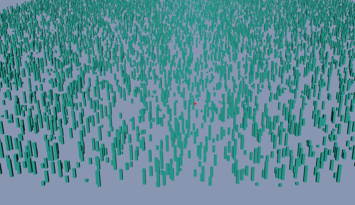
3. 页面显示
4. 源码地址
https://github.com/WhatGIS/maptalkMap/tree/main/threelayer/demo