一,插件
leaflet的官网上,plugins很多。但是这个插件:Leaflet.Shapefile 不太管用,https://github.com/calvinmetcalf/leaflet.shapefile
可以启动的方法用了作者的另外一个插件:https://github.com/calvinmetcalf/shapefile-js,不是直接用L.Shapefile这个拓展结构,
需要引入shapefile-js的插件
下载地址:https://github.com/calvinmetcalf/leaflet.shapefile/blob/gh-pages/shp.js
var geo = L.geoJson({features:[]},{onEachFeature:function popUp(f,l){
            var out = [];
            if (f.properties){
                for(var key in f.properties){
                    out.push(key+": "+f.properties[key]);
                    }
                l.bindPopup(out.join("<br />"));
            }
            }});//加载zip打包的shapefile类型文件
 var base=''
 shp(base).then(function(data){
        geo.addData(data);
          });
另,由于解析shp文件的异步方法,如下:
shp().then()
用到了AJAX,所以需要加载本地文件,便触发了同源约束,需要开启VScode的live server。
二,天地图上加载shapefile
//请求天地图服务
let tmaps=L.layerGroup([
                L.tileLayer(),
                L.tileLayer()
                ])
//解析shapefile文件
var geo = L.geoJson({features:[]},{onEachFeature:function popUp(f,l){
       var out = [];
       if (f.properties){
       for(var key in f.properties){
             out.push(key+": "+f.properties[key]);
                 }
             l.bindPopup(out.join("<br />"));
            }
            }});
//需要shapefile文件的zip压缩包
var base='地址.zip'
shp(base).then(function(data){
        geo.addData(data);
         });
//把两种图加载到地图容器
var map=L.map('map',{
      crs:L.CRS.EPSG4326,
      center: [],
      zoom:4,
      zoomControl: false,
      attributionControl: false,
      closePopupOnClick: false,
      layers:[tmaps,geo]
      })
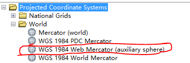
天地图的投影方式是EPSG4326,leaflet的默认投影为EPSG3857,需要把对应的shapefile也投影成与匹配的投影,在arcgis里选择网络墨卡托

Web Mercator与EPSG4326的关系在这里:https://www.cnblogs.com/E7868A/p/11460865.html