我们利用鼠标工具来实现多边形编辑,引入鼠标工具插件:
<script src="http://webapi.amap.com/maps?v=1.3&key=您申请的key值&plugin=AMap.PolyEditor"></script>
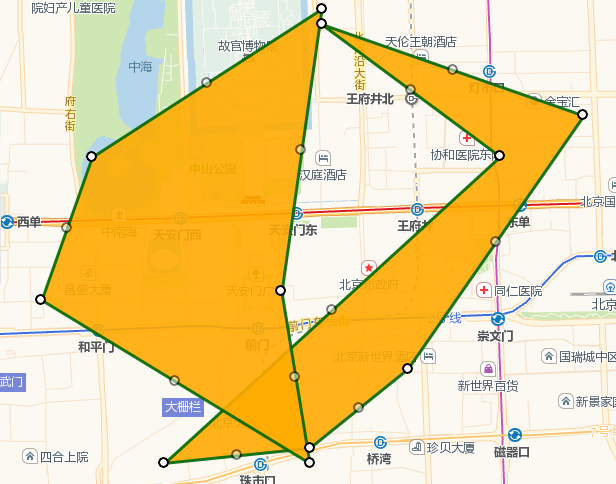
绘制多边形,如此绘制2个。您也可以绘制多个。
 //在地图上绘制折线
    var editor={};
    editor._polygon1=(function(){
        var arr = [ //构建多边形经纬度坐标数组
        [116.403322,39.920255],
        [116.410703,39.897555],
        [116.402292,39.892353],
        [116.389846,39.891365]
        ]
        return new AMap.Polygon({
            map: map,
            path: arr
        });
    })();
绘制完毕,打开多边形可编辑属性。即可编辑多边形。
editor._polygonEditor1= new AMap.PolyEditor(map, editor._polygon1);
editor._polygonEditor1.open();
截图如下:
全部源代码:
<!doctype html>
<html>
<head>
    <meta charset="utf-8">
    <meta http-equiv="X-UA-Compatible" content="IE=edge">
    <meta name="viewport" content="initial-scale=1.0, user-scalable=no, width=device-width">
    <title>编辑折线、多边形、圆</title>
    <link rel="stylesheet" href="http://cache.amap.com/lbs/static/main1119.css"/>
    <script src="http://webapi.amap.com/maps?v=1.3&key=您申请的key值&plugin=AMap.PolyEditor"></script>

</head>
<body>
<div id="container"></div>
<script>
    var editorTool, map = new AMap.Map("container", {
        resizeEnable: true,
        center: [116.403322, 39.900255],//地图中心点
        zoom: 13 //地图显示的缩放级别
    });
    //在地图上绘制折线
    var editor={};
    editor._polygon1=(function(){
        var arr = [ //构建多边形经纬度坐标数组
        [116.403322,39.920255],
        [116.410703,39.897555],
        [116.402292,39.892353],
        [116.389846,39.891365]
        ]
        return new AMap.Polygon({
            map: map,
            path: arr
        });
    })();

    editor._polygon2=(function(){
        var arr = [ //构建多边形经纬度坐标数组
        [116.403322,39.921255],
        [116.410703,39.891555],
        [116.402292,39.891353],
        [116.389846,39.891365]
        ]
        return new AMap.Polygon({
            map: map,
            path: arr
        });
    })();

    map.setFitView();
   editor._polygonEditor1= new AMap.PolyEditor(map, editor._polygon1);
   editor._polygonEditor1.open();

      editor._polygonEditor2= new AMap.PolyEditor(map, editor._polygon2);
   editor._polygonEditor2.open();


</script>
</body>
</html>