一、WFS简介
OGC的WMS和WMTS规范都是有关空间数据显示的标准,而WFS(Web Feature Service)则允许用户在分布式的环境下通过HTTP对空间数据进行增、删、改、查。
具体来说,WebGIS服务器除了能够返回一张张地图图像之外,还可以返回绘制该地图图像所使用的真实地理数据。用户利用这些传输到客户端的地理数据可以进行数据渲染可视化、空间分析等操作。而前后端的这种数据交互就是基于WFS规范的。
那么也就能很清楚的说明WMS与WFS之间的区别了。WMS是由服务器将地图图像发送给客户端,而WFS是服务器将矢量数据发送给客户端。也就是在使用WMS时地图由服务器绘制,在使用WFS时地图由客户端绘制。另外最最重要的,使用WFS可以对WebGIS服务器中的地理数据(存储在空间数据库中)直接进行增、删、改、查。

二、WFS的种类与操作
WFS服务一般支持如下功能:
GetCapabilities —— 获取WFS服务的元数据(介绍服务中的要素类和支持的操作)
DescribeFeatureType —— 获取WFS服务支持的要素类的定义(要素类的元数据,比如要素包含哪些字段)
GetFeature —— 获取要素数据
GetGmlObject —— 通过XLink获取GML对象
Transaction —— 创建、更新、删除要素数据的事务操作
LockFeature —— 在事务过程中锁定要素
实际中,WebGIS服务器针对这些功能并不是必须全部实现,而是实现全部或部分。
因此,根据依据这些功能的支持与否,可以将WFS分为3类:
Basic WFS —— 必须支持GetCapabilities、DescribeFeature Type、GetFeature功能
XLink WFS —— 必须在Basic WFS基础上加上GetGmlObject操作
Transaction WFS —— 也称为WFS-T,必须在Basic WFS基础上加上Transaction功能以及支持编辑数据,另外也可以加上GetGmlObject或LockFeature功能
三、GetCapabilities(获取元数据)
GetCapabilities的KVP格式请求需要以下参数:
示例:
获取本机安装的GeoServer中WFS服务的元数据:
http://localhost:8080/geoserver/wfs?SERVICE=WFS&VERSION=1.1.0&REQUEST=GetCapabilities
GeoServer将会返回一个XML文件(由于内容太多,这里就不列出来了),里面包含了关于这个GeoServer服务器的WFS服务的所有元数据,比如,包含哪些要素类,支持哪些操作等等。
四、DescribeFeatureType(获取要素类的元数据)
DescribeFeatureType的KVP格式请求需要以下参数:
示例:
获取本机GeoServer中guangdong:gd_roads要素类的元数据:
http://localhost:8080/geoserver/wfs?SERVICE=WFS&VERSION=1.1.0&REQUEST=DescribeFeatureType&TYPENAME=guangdong:gd_roads
GeoServer返回一个XML文件:
<xsd:schema xmlns:xsd="http://www.w3.org/2001/XMLSchema" xmlns:gml="http://www.opengis.net/gml" xmlns:guangdong="http://localhost:8084/geoserver/guangdong" elementFormDefault="qualified" targetNamespace="http://localhost:8084/geoserver/guangdong">
<xsd:import namespace="http://www.opengis.net/gml" schemaLocation="http://localhost:8080/geoserver/schemas/gml/3.1.1/base/gml.xsd"/>
<xsd:complexType name="gd_roadsType">
<xsd:complexContent>
<xsd:extension base="gml:AbstractFeatureType">
<xsd:sequence>
<xsd:element maxOccurs="1" minOccurs="0" name="the_geom" nillable="true" type="gml:MultiLineStringPropertyType"/>
<xsd:element maxOccurs="1" minOccurs="0" name="osm_id" nillable="true" type="xsd:string"/>
<xsd:element maxOccurs="1" minOccurs="0" name="code" nillable="true" type="xsd:int"/>
<xsd:element maxOccurs="1" minOccurs="0" name="fclass" nillable="true" type="xsd:string"/>
<xsd:element maxOccurs="1" minOccurs="0" name="ref" nillable="true" type="xsd:string"/>
<xsd:element maxOccurs="1" minOccurs="0" name="oneway" nillable="true" type="xsd:string"/>
<xsd:element maxOccurs="1" minOccurs="0" name="maxspeed" nillable="true" type="xsd:int"/>
<xsd:element maxOccurs="1" minOccurs="0" name="layer" nillable="true" type="xsd:double"/>
<xsd:element maxOccurs="1" minOccurs="0" name="bridge" nillable="true" type="xsd:string"/>
<xsd:element maxOccurs="1" minOccurs="0" name="tunnel" nillable="true" type="xsd:string"/>
<xsd:element maxOccurs="1" minOccurs="0" name="type" nillable="true" type="xsd:long"/>
</xsd:sequence>
</xsd:extension>
</xsd:complexContent>
</xsd:complexType>
<xsd:element name="gd_roads" substitutionGroup="gml:_Feature" type="guangdong:gd_roadsType"/>
</xsd:schema>
其中,name就是指gd_roads要素类所具有的字段,而type就是该字段数据的数据类型。
五、GetFeature(获取要素数据)
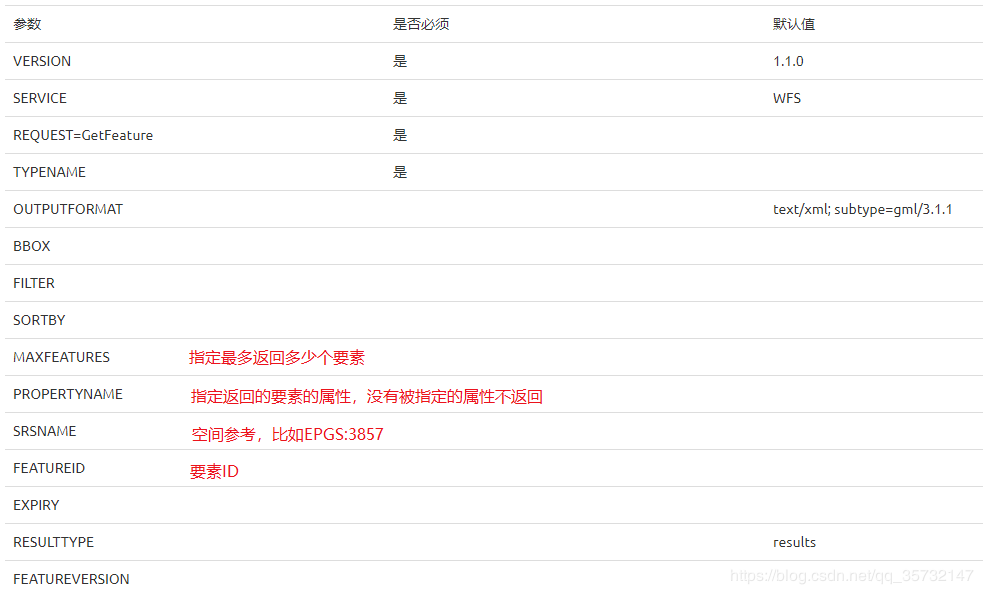
GetFeature的KVP格式请求需要以下参数:

示例:
①返回本机GeoServer中guangdong:gd_roads要素类的要素ID为gd_roads.1的要素,返回数据格式指定为json:
http://localhost:8080/geoserver/wfs?SERVICE=WFS&VERSION=1.1.0&REQUEST=GetFeature&TYPENAME=guangdong:gd_roads&OUTPUTFORMAT=application/json&FEATUREID=gd_roads.1
②返回本机GeoServer的guangdong:gd_roads要素类中的10个要素,返回数据格式指定为json:
http://localhost:8080/geoserver/wfs?SERVICE=WFS&VERSION=1.1.0&REQUEST=GetFeature&TYPENAME=guangdong:gd_roads&OUTPUTFORMAT=application/json&MAXFEATURES=10
六、Transaction(对要素数据增、删、改)
Transaction的KVP格式请求需要以下参数:

目前Transaction的KVP格式请求只支持Delete操作(Insert和Update必须通过XML格式请求)。
示例:
删除本机GeoServer的guangdong:gd_roads要素类中的ID为gd_roads.1的要素:
http://localhost:8080/geoserver/wfs?SERVICE=WFS&VERSION=1.1.0&REQUEST=Transaction&TYPENAME=guangdong:gd_roads&FEATUREID=gd_roads.1
参考链接: