zoukankan      html  css  js  c++  java
  • 基于BIM+GIS钢结构全生命周期管理平台项目

        “BIM+GIS钢结构全生命周期管理平台”平台平台由业务平台、交互平台、移动端三端组成。平台通过BIM技术、信息化技术、GIS技术、物联网技术、集成技术的应用,有效推进钢结构BIM全生命周期智能建造,实现“精品工程、智能丰台”的目标。

      2、功能结构

      项目中应用了BIM技术、GIS技术、信息化管理等技术于钢结构项目管理中,包括展示平台、业务平台、移动端三部分组成应用重点如下:

      (1)实现基于BIM模型查看任意构件设计管理、深化设计、预制加工、物流运输、现场管理、交验管理构件的全生命周期信息,辅助项目管理,直观将移动端、两家业务系统采集的数据直观进行展示。

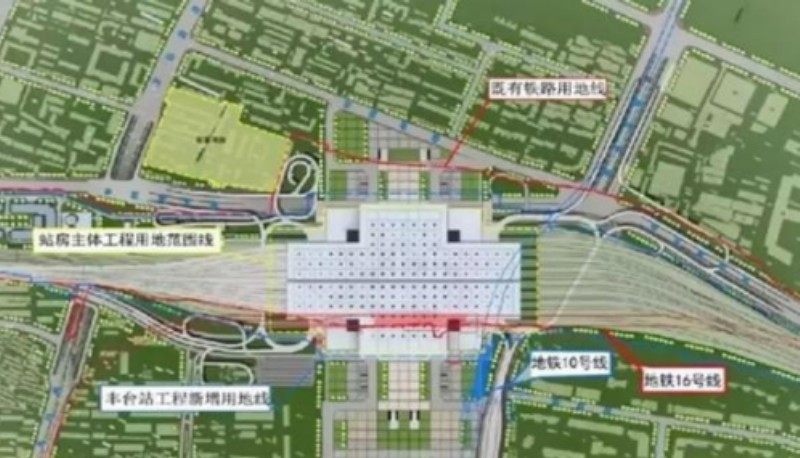
      (2)实现了GIS技术、BIM技术与智慧工地融合能够在GIS+BIM场景中随时随地的查看现场智慧工地如监控设备、环境监测、劳务数据、塔吊数据、基坑监测点数据、大体积混凝土测温数据等均与场景对应实现位置信息3维一体。

      (3)实现了智慧工厂数据到项目系统中数据的无缝衔接,平台通过接口成功获取了两件钢结构工厂供应商生产阶段数据,实现数据的无缝衔接,数据同步。

    
    <!DOCTYPE html>
    <html>
    <head>
    <meta charset="utf-8">
    <title data-i18n="resources.title_closestFacilitiesService"></title>
    <style type="text/css">
            body {
                margin: 0;
                overflow: hidden;
                background: #fff;
                 100%;
                height: 100%
            }
    
            #map {
                position: absolute;
                 100%;
                height: 100%;
            }
    
            #toolbar {
                position: absolute;
                top: 50px;
                right: 10px;
                 320px;
                text-align: center;
                z-index: 100;
                border-radius: 4px;
            }
        </style>
    </head>
    <body>
    <div id="toolbar" class="panel panel-primary">
    <div class='panel-heading'>
    <h5 class='panel-title text-center' data-i18n="resources.text_closestFacilitiesService"></h5></div>
    <div class='panel-body content'>
    <div class='panel'>
    <div class='input-group'>
    <span class='input-group-addon' data-i18n="resources.text_weightField"></span>
    <select class='form-control' id='edgeWeightNames'>
    <option>length</option>
    <option>time</option>
    </select>
    </div>
    </div>
    <div class='panel'>
    <div class='input-group'>
    <span class='input-group-addon' data-i18n="resources.text_turnField"></span>
    <select class='form-control' id='turnNodeWeightNames'>
    <option>TurnCost</option>
    </select>
    </div>
    </div>
    <input type="button" class="btn btn-default" data-i18n="[value]resources.text_input_value_eventPoint" onclick="selectEventPoint()"/>&nbsp;
    <input type="button" class="btn btn-default" data-i18n="[value]resources.text_input_value_submit" onclick="findClosestFacilities()"/>&nbsp;
    <input type="button" class="btn btn-default" data-i18n="[value]resources.text_input_value_clear" onclick="clearElements()"/>
    </div>
    </div>
    <div id="map"></div>
    <script type="text/javascript" include="bootstrap,widgets.alert" src="../js/include-web.js"></script>
    <script type="text/javascript" exclude="iclient-classic" src="../../dist/classic/include-classic.js"></script>
    <script>
        var host = window.isLocal ? window.server : "https://iserver.supermap.io";
        var  map, layer, vectorLayer, markerLayer1,
            markerLayer2, drawPoint, eventPoint, n = 0,
            facilityPoints = [
                new SuperMap.Geometry.Point(6000, -5500),
                new SuperMap.Geometry.Point(5500, -2500),
                new SuperMap.Geometry.Point(2500, -3500)],
            style = {
                strokeColor: "#304DBE",
                strokeWidth: 3,
                pointerEvents: "visiblePainted",
                fill: false
            },
            url1 = host + "/iserver/services/map-changchun/rest/maps/长春市区图",
            url2 = host + "/iserver/services/transportationanalyst-sample/rest/networkanalyst/RoadNet@Changchun";
    
        init();
    
        function init() {
            vectorLayer = new SuperMap.Layer.Vector("Vector Layer");
            drawPoint = new SuperMap.Control.DrawFeature(vectorLayer, SuperMap.Handler.Point);
            drawPoint.events.on({"featureadded": drawCompleted});
            map = new SuperMap.Map("map", {
                controls: [
                    new SuperMap.Control.ScaleLine(),
                    new SuperMap.Control.Zoom(),
                    new SuperMap.Control.Navigation({
                        dragPanOptions: {
                            enableKinetic: true
                        }
                    }),
                    drawPoint], units: "m"
            });
            map.addControl(new SuperMap.Control.LayerSwitcher(), new SuperMap.Pixel(42, 80));
            layer = new SuperMap.Layer.TiledDynamicRESTLayer("Changchun", url1, {
                transparent: true,
                cacheEnabled: true
            }, {maxResolution: "auto"});
            layer.events.on({"layerInitialized": addLayer});
            markerLayer1 = new SuperMap.Layer.Markers("Markers");
            markerLayer2 = new SuperMap.Layer.Markers("Markers");
    
            var size = new SuperMap.Size(44, 40),
                offset = new SuperMap.Pixel(-(size.w / 2), -size.h),
                icon1 = new SuperMap.Icon("./images/marker-gold.png", size, offset),
                icon2 = new SuperMap.Icon("./images/marker-gold.png", size, offset),
                icon3 = new SuperMap.Icon("./images/marker-gold.png", size, offset);
            markerLayer1.addMarker(new SuperMap.Marker(new SuperMap.LonLat(6000, -5500), icon1));
            markerLayer1.addMarker(new SuperMap.Marker(new SuperMap.LonLat(5500, -2500), icon2));
            markerLayer1.addMarker(new SuperMap.Marker(new SuperMap.LonLat(2500, -3500), icon3));
        }
    
        function addLayer() {
            map.addLayers([layer, vectorLayer, markerLayer1, markerLayer2]);
            map.setCenter(new SuperMap.LonLat(4503.6240321526, -3861.911472192499), 1);
        }
    
        function selectEventPoint() {
            widgets.alert.clearAlert();
            clearElements();
            drawPoint.activate();
        }
    
        function drawCompleted(drawGeometryArgs) {
            var point = drawGeometryArgs.feature.geometry,
                size = new SuperMap.Size(44, 33),
                offset = new SuperMap.Pixel(-(size.w / 2), -size.h),
                icon = new SuperMap.Icon("./images/marker.png", size, offset);
            markerLayer2.addMarker(new SuperMap.Marker(new SuperMap.LonLat(point.x, point.y), icon));
            eventPoint = point;
            n++;
            if (n >= 1) {
                drawPoint.deactivate();
            }
        }
    
        function findClosestFacilities() {
            widgets.alert.clearAlert();
            drawPoint.deactivate();
            if (!eventPoint) {
                widgets.alert.showAlert(resources.msg_eventPoint,true);
                return;
            }
            var findClosestFacilitiesService, parameter, analystParameter, resultSetting;
            resultSetting = new SuperMap.REST.TransportationAnalystResultSetting({
                returnEdgeFeatures: true,
                returnEdgeGeometry: true,
                returnEdgeIDs: true,
                returnNodeFeatures: true,
                returnNodeGeometry: true,
                returnNodeIDs: true,
                returnPathGuides: true,
                returnRoutes: true
            });
            var edgeWeightNamesSelect = document.getElementById("edgeWeightNames");
            var weightFieldName = edgeWeightNamesSelect.options[edgeWeightNamesSelect.selectedIndex].text;
    
            var turnWeightFieldSelect = document.getElementById("turnNodeWeightNames");
            var turnNodeWeightNames = turnWeightFieldSelect.options[turnWeightFieldSelect.selectedIndex].text;
            analystParameter = new SuperMap.REST.TransportationAnalystParameter({
                resultSetting: resultSetting,
                turnWeightField: turnNodeWeightNames,
                weightFieldName: weightFieldName
            });
            parameter = new SuperMap.REST.FindClosestFacilitiesParameters({
                event: eventPoint,
                expectFacilityCount: 1,
                isAnalyzeById: false,
                facilities: facilityPoints,
                parameter: analystParameter
            });
            findClosestFacilitiesService = new SuperMap.REST.FindClosestFacilitiesService(url2, {
                eventListeners: {"processCompleted": processCompleted}
            });
            findClosestFacilitiesService.processAsync(parameter);
        }
    
        function processCompleted(findClosestFacilitiesEventArgs) {
            var result = findClosestFacilitiesEventArgs.result,
                features = [];
            if (result.facilityPathList) {
                for (var i = 0, facilityPathList = result.facilityPathList, len = facilityPathList.length; i < len; i++) {
                    var feature = new SuperMap.Feature.Vector();
                    feature.geometry = facilityPathList[i].route;
                    feature.style = style;
                    features.push(feature);
                }
            }
            vectorLayer.addFeatures(features);
        }
    
        function clearElements() {
            widgets.alert.clearAlert();
            eventPoint = null;
            n = 0;
            markerLayer2.clearMarkers();
            vectorLayer.removeAllFeatures();
        }
    </script>
    </body>
    </html>


    技术交流 省涯 QQ:2252224326 2252224326@qq.com 版权所有 http://blog.sina.com.cn/u/6029512413
  • 相关阅读:
    编程总结2
    编程总结3
    《秋季学期学习总结》
    《人生路上对我影响最大的三位老师》
    第八周编程总结
    第七周编程总结
    第六周编程总结
    第五周作业
    第四周编程总结
    第三周编程总结
  • 原文地址:https://www.cnblogs.com/shengya/p/14931886.html
Copyright © 2011-2022 走看看