以实现鼠标拖拽文本图层为例
GitHub:ArcGIS拖拽文本
作者:狐狸家的鱼
目的是利用鼠标进行拖拽。
实现两种模式,一种是屏幕上的拖拽,第二种是地图上图层的挪动。
屏幕上的拖拽其实跟ArcGIS没有联系,用qml就能写,但是地图图层上的挪动,就需要考虑到ArcGIS 图层的问题了。
鼠标拖拽都跟鼠标事件有关联,MouseEvent中的Drag()事件和onMousePressedAndHeld()以及onMouseReleased()事件。

1.屏幕上的拖拽

2.地图上图层的挪动
1、屏幕上的拖拽
为了方便,把两种方式写在了一个项目文件中。
Text{
            id:tex;
            text: "我还可以再挪两步(●ˇ∀ˇ●)";
            font.pointSize: 15;
            color: "yellow";
            //font.bold: true;
            MouseArea{
                id:dragArea;
                anchors.fill: tex;
                drag.target: tex;
                acceptedButtons: Qt.RightButton;
                drag.axis: Drag.XAndYAxis
                drag.minimumX: 0
                drag.maximumX: mapView.width - tex.width
                drag.minimumY: 0
                drag.maximumY: mapView.height - tex.height
            }

        }
2、图层的拖拽
这里是左键点击添加一个文本,然后用右键进行拖拽活动。
因为地图上的左键按压时会挪动地图,所以选择右键拖拽文本。
在ArcGIS中,MouseEvent中有个属性叫 button:int
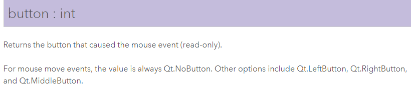
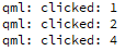
返回产生鼠标事件的按钮,经过打印可以得到左键=1,中键=4,右键=2。以此来判断鼠标的左右键。
onMouseClicked: {//打印鼠标事件的按钮
            console.log("clicked:",mouse.button);
}
属性解释说明了,鼠标按下事件的按钮有左键、右键、中键,但是对于鼠标移动事件,返回值永远是Qt.NoButton。所以在地图上利用鼠标进行拖动可能不行,只能进行点击挪动。
MapView {
        id:mapView;
        anchors.fill: parent
        // set focus to enable keyboard navigation
        focus: true

        Map {
            //BasemapTopographic {}
            BasemapImageryWithLabels {}
        }
        onMouseClicked: {
            console.log("clicked:",mouse.button);
            if(mouse.button === 1){//鼠标左键
                textGraphic = ArcGISRuntimeEnvironment.createObject("Graphic");
                textGraphic.geometry = mouse.mapPoint;
                textGraphic.symbol = textSymbol;
                addTextGraphicsOverlayer.graphics.append(textGraphic);

            }
        }
        onMousePressed: {//鼠标右键
            if(mouse.button === 2){
                textGraphic.geometry = mouse.mapPoint;
            }
        }
        onMouseReleased: {
            if(mouse.button === 2){
                textGraphic.geometry = mouse.mapPoint;
            }
        }

        GraphicsOverlay{
            id:addTextGraphicsOverlayer;

        }
        TextSymbol{
            id:textSymbol;
            size: 15;
            color: "yellow"
            text: "我可以在地图上走两步(。^▽^)"
        }
}
如有认识偏差和错误,还望指正,谢谢(づ ̄ 3 ̄)づ