平面坐标系模型
在部分项目中,三维数数据是根据平面坐标系进行建模的,并且以为某些需求,还不能转为经纬度坐标系,所以就需要一些手段——将模型的坐标通过计算转换后,将场景放置在了经线0°的位置(本初子午线)。
1.iDesktop中的操作
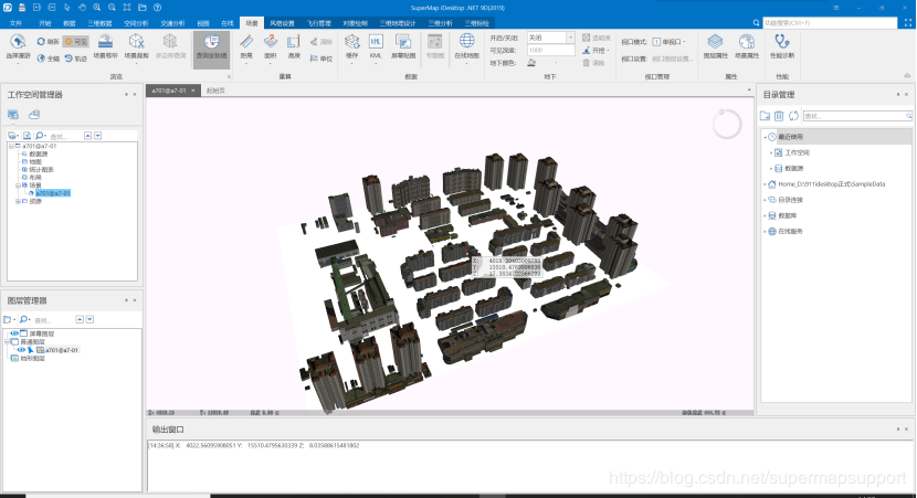
加载模型数据到平面场景中,确认无误后,生成场景缓存(s3m),并且通过查询坐标值找到模型的中心点。
2.Webgl中的操作(代码)
iServer中将该工作空间发布为三维服务。发布后用由于Cesium不支持加载平面坐标系三维,所以在iserver中预览会没有任何模型,甚至报错。
在webgl中加载发布的模型,首先viewer的sceneMode场景模式要设置为哥伦布模式(Cesium.SceneMode.COLUMBUS_VIEW)。然后再通过scene.open()添加模型。
代码:
viewer = new Cesium.Viewer(‘cesiumContainer’);
viewer.scene.mode = Cesium.SceneMode.COLUMBUS_VIEW;
此时模型已经添加到场景中,但是Cesium无法识别平面坐标系坐标,无法定位到模型位置,因此需要对刚才在idesktop中获取的中心点进行转换。然后设置camera属性,飞到模型中心。
转换代码:
var point = new Cesium.Cartesian3(X, Y, Z);
var pointCartographic = scene.camera._projection.unproject(point);
var pointCX = Cesium.Math.toDegrees(pointCartographic.longitude);
var pointCY = Cesium.Math.toDegrees(pointCartographic.latitude);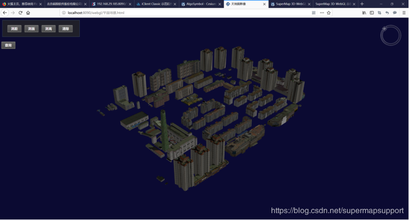
到此webgl已经可以加载平面坐标系模型并且展示,如果想完全模拟idesktop中的平面场景,可以通过替换球面背景图来实现。
3.部分三维分析功能无法使用
截至2019/01/16,如果跟图层操作较为密切的功能是无法实现的,如:地形挖方(需要地形数据),阴影分析,光照分析,控高分析(需要地形数据)等
正常使用且常用的:可视域分析,通视分析,天际线分析,场景飞行,测量;
4.完整代码
// 加载平面场景模型
function onload(Cesium) {
      //初始化viewer部件
      viewer = new Cesium.Viewer('cesiumContainer');
      var scene = viewer.scene;
      var widget = viewer.cesiumWidget;
              viewer.scene.mode = Cesium.SceneMode.COLUMBUS_VIEW;
      viewer._cesiumWidget._creditContainer.style.display = 'none';
      try {
        //打开所发布三维服务下的所有图层
       var url5 = "http://localhost:8090/iserver/services/3D-a701-a7-01/rest/realspace";
        var promise = scene.open(url5);
        Cesium.when.all(promise, function(layers) {

          layers.forEach(function(item, index) {
            item.ignoreNormal = true // 获取或者设置是否在GPU中自动计算法线
            item.clearMemoryImmediately = true // 是否及时释放内存
          })

          var point = new Cesium.Cartesian3(4057.48, 1554.01, 10);
          var pointCartographic = scene.camera._projection.unproject(point);
          var pointCX = Cesium.Math.toDegrees(pointCartographic.longitude);
          var pointCY = Cesium.Math.toDegrees(pointCartographic.latitude);

          //设置相机位置,定位至模型
          scene.camera.flyTo({
            destination: Cesium.Cartesian3.fromDegrees(pointCX, pointCY, pointCartographic.height),
            orientation: {
              heading: 0,
              pitch: 0,
              roll: 0
            }
          });
        }, function(e) {
          if (widget._showRenderLoopErrors) {
            var title = '加载SCP失败,请检查网络连接状态或者url地址是否正确?';
            widget.showErrorPanel(title, undefined, e);
          }
        });
      } catch (e) {
        if (widget._showRenderLoopErrors) {
          var title = '渲染时发生错误,已停止渲染。';
          widget.showErrorPanel(title, undefined, e);
        }
      }
    }