高德地图实现轨迹回放的方式之一:使用高德地图官方api中UI组件库中的轨迹展示。通过轨迹展示创建巡航器,实现轨迹回放。创建巡航器实现轨迹回放的好处就是回放速度随时控制随时变化,不好的浏览器必须支持canvas(IE8及以下不支持)。效果图如下: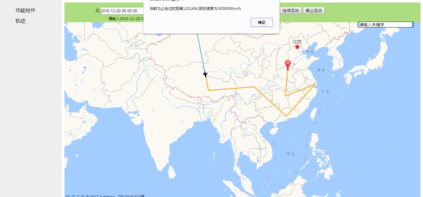
看主要的代码
  1 AMapUI.load(['ui/misc/PathSimplifier'], function    (PathSimplifier) {
  2
  3         if (!PathSimplifier.supportCanvas) {
  4          alert('当前环境不支持 Canvas!');
  5          return;
  6      }
  7     //回放路径等配置项,参考官方api
  8     var defaultRenderOptions = {
  9             pathNavigatorStyle: {
 10                 16,
 11                 height:16,
 12                 autoRotate:true,
 13                 lineJoin:'round',
 14                 content:'defaultPathNavigtor',
 15                 fillStyle:'#087EC4',
 16                 strokeStyle:'#116394',
 17                 lineWidth:1,
 18                 pathLinePassedStyle: {
 19                     lineWidth:2,
 20                     strokeStyle:'rgba(0, 160, 220, 0.8)',
 21                     borderWidth:1,
 22                     borderStyle:'#eee',
 23                     dirArrowStyle:false
 24                 }
 25             }
 26         };
 27
 28     var pathSimplifierIns = new PathSimplifier({
 29         zIndex: 100,
 30         map: map,
 31         getPath: function(pathData, pathIndex) {
 32             return pathData.path;
 33         },
 34         getHoverTitle: function(pathData, pathIndex, pointIndex) {
 35             //返回鼠标悬停时显示的信息
 36             if (pointIndex >= 0) {
 37                 //鼠标悬停在某个轨迹节点上
 38                 return pathData.name + ',点:' + pointIndex + '/' + pathData.path.length;
 39             }
 40             //鼠标悬停在节点之间的连线上
 41             return pathData.name + ',点数量' + pathData.path.length;
 42         },
 43         renderOptions: defaultRenderOptions
 44     });
 45
 46     window.pathSimplifierIns = pathSimplifierIns;
 47     //根据数据来绘制路线
 48     pathSimplifierIns.setData([{
 49         name: '轨迹',
 50         path: lineArr
 51     }]);
 52     //创建巡航器
 53     var navg = pathSimplifierIns.createPathNavigator(0,{
 54             loop: true,//是否循环播放
 55             speed: parseInt(speed.value),//回放速度控制,这里使用的是select下拉列表value值控制
 56             pathNavigatorStyle: {
 57                 24,
 58                 height:24,
 59                 content: PathSimplifier.Render.Canvas.getImageContent('image/plane.png'),//自定义巡航器样式
 60                 strokeStyle:null,
 61                 fillStyle:null
 62             }
 63         });
 64     //控制播放按钮
 65        start.onclick =    function  (){
 66             navg.start();
 67         }
 68
 69     pause.onclick =    function  (){
 70             navg.pause();
 71
 72             alert('当前为止走过的距离'+parseInt(navg.getMovedDistance()/1000)+'KM,回放速度为:'+parseInt(navg.getSpeed())+'Km/h');
 73
 74         }
 75
 76     resume.onclick =    function (){
 77             navg.resume();
 78
 79         }
 80     stop.onclick =    function (){
 81             navg.stop();
 82
 83         }
 84
 85
 86         //下拉列表value值改变速度改变
 87         speed.onchange=function(){
 88             var spe = speed.value;
 89             navg.setSpeed(spe);
 90
 91         };
 92
 93     //起点终点标记
 94     var startPot = lineArr[0];
 95
 96       var endPot = lineArr[lineArr.length-1];
 97
 98       var stmarker = new AMap.Marker({
 99             map: map,
100             position: [startPot[0], startPot[1]], //基点位置
101             icon: "https://webapi.amap.com/theme/v1.3/markers/n/start.png",
102             zIndex: 10
103         });
104         var endmarker = new AMap.Marker({
105             map: map,
106             position: [endPot[0], endPot[1]], //基点位置
107             icon: "https://webapi.amap.com/theme/v1.3/markers/n/end.png",
108             zIndex: 10
109         });
110
111 });
以上就是高德地图实现轨迹回放方法之一。此高德地图UI组件需要在服务器环境下运行,详细代码地址github,仅作学习总结只用!