-
此文为笔者初次尝试map组件后的学习笔记,由于笔者功力有限,如有不足,还望指教
-
参考资料:
map组件
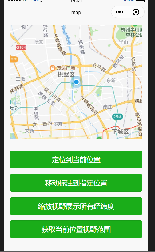
map组件相关api效果图:
直接上代码(其中有我个人理解的注释):
- wxml
         <view class="page-body">
           <view class="page-section page-section-gap">
             <map
               id="myMap"
               style=" 100%; height: 300px;"
               latitude="{{latitude}}"
               longitude="{{longitude}}"
               markers="{{markers}}"
               show-location
             ></map>
           </view>
           <view class="btn-area">
             <button bindtap="getCenterLocation" class="page-body-button" type="primary">定位到当前位置</button>
             <button bindtap="translateMarker" class="page-body-button" type="primary">移动标注到指定位置</button>
             <button bindtap="includePoints" class="page-body-button" type="primary">缩放视野展示所有经纬度</button>
              <button bindtap="getRegion" class="page-body-button" type="primary">获取当前位置视野范围</button>
           </view>
         </view>
- wxss
         page {
           background-color: #f8f8f8;
           height: 100%;
           font-size: 32rpx;
           line-height: 1.6;
         }

         .page-body {
           padding: 20rpx 0;
         }

         .page-section-gap {
           box-sizing: border-box;
           padding: 0 30rpx;
         }

         .btn-area {
           margin-top: 60rpx;
           box-sizing: border-box;
            100%;
           padding: 0 30rpx;
         }

         .page-body-button {
           margin-bottom: 30rpx;
         }
- javascript
         Page({
           data: {
             //纬度
             latitude: 30.319739999999985,
             //经度
             longitude: 112.222,
             //标记点
             markers: [{
               //标记点 id
               id: 1,
               //标记点纬度
               latitude: 32.319739999999985,
               //标记点经度
               longitude: 120.14209999999999,
               name: '行之当前的位置'
             }],
           },
           onReady: function (e) {
             //获取map上下文
             //参数:
             //string mapId
             //Object this
             this.mapCtx = wx.createMapContext('myMap')
           },
           //获取当前位置经纬度,并把定位到相应的位置
           getCenterLocation: function () {
             //获取当前位置:经纬度
             this.mapCtx.getCenterLocation({
               success:res=>{
                 //获取成功后定位到相应位置
                 console.log(res);
                 //参数对象中设置经纬度,我这里设置为获取当前位置得到的经纬度值
                 this.mapCtx.moveToLocation({
                   longitude:res.longitude,
                   latitude:res.latitude
                 })
               }
             })
           },
           //移动标记(marker)到指定位置
           translateMarker: function() {
             //平移marker
             this.mapCtx.translateMarker({
               //要平移的marker的id
               markerId: 1,
               //移动过程中是否自动旋转 marker
               autoRotate: true,
               //动画持续时长,平移与旋转分别计算
               duration: 1000,
               //平移到的目的地,参数为经纬度
               destination: {
                 latitude:33,
                 longitude:113.3345211,
               },
               //平移动画后的回调函数
               animationEnd() {
                 console.log('动画结束')
               }
             })
           },
           //缩放视野展示所有经纬度
           includePoints: function() {
             this.mapCtx.includePoints({
               //坐标点形成的矩形边缘到地图边缘的距离,单位像素。
               padding: [10],
               //有哪些要缩放的点
               points: [{
                 latitude:23.10229,
                 longitude:113.3345211,
               }, {
                 latitude:24.00229,
                 longitude:113.545211,
               }],
               success:res=>{
                 console.log("缩放成功")
               }
             })
           },
           //获取当前位置视野范围
           getRegion:function(){
             this.mapCtx.getRegion({
               success:res=>{
                 //东北角经纬度
                 console.log(res.northeast);
                 //西南角经纬度
                 console.log(res.southwest);
               }
             })
           }
         })
以上就是笔者对map组件的初次尝试了。