引言
好久没写博客了,因为最近在准备考研,所以博客一直都没有写。之前完成的任务也没有写,今天正好完成一个工作,写写博客。
展示
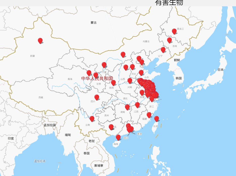
任务
将图片中的信息改成,地名,经度,纬度,相关害虫,然后在中国地图展示
一开始用的是百度地图逆地理编码,不得不吐槽,太辣鸡了。于是选了高德(yyds)。
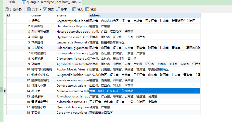
思路:把所有地区放到一个列表,并去重。然后遍历每个地区,判断该地区在哪个害虫对应的地区,并把害虫名字添加到相关害虫这列中。最后通过后台传值,在前端页面展示。
地区处理:
#-*- codeing = utf-8 -*-
#@Time : 2021/5/26 10:27
#@Author : 杨晓
#@File : test.py
#@Software: PyCharm
import requests
import pymysql

# 返回所有地区和昆虫数据
def get_all_diqu():
    db = pymysql.connect(host="localhost", user="root", password="root", database="reblyhc")
    # 使用cursor()方法获取操作游标
    cursor = db.cursor()
    # try:
    # 执行SQL语句
    cursor.execute("select * from quanguo")
    # 获取所有记录列表
    results = cursor.fetchall()
    data = []
    diqu = []
    for row in results:
        temp = {}
        temp["id"] = row[0]
        temp["cname"] = row[1]
        temp["ename"] = row[2]
        temp["address"] = row[3]
        data.append(temp)
        for one in row[3].split("、"):
            diqu.append(one)
    db.close()
    return list(set(diqu)),data

## 插入信息
def insert_info(name,lng,lat,insects):
    # port是整型 mysql是utf8 不是utf-8
    con = pymysql.connect(host="localhost", port=3306, user='root', password='root', charset='utf8', db='reblyhc')
    # 在pymysql中插入删除修改默认是一个事务
    try:
        with con.cursor() as cursor:  # 获得一个游标
            result = cursor.execute('insert into address values(%s,%s,%s,%s,%s)',(0,name,lng,lat,insects))
            if result == 1:
                print("插入成功")
                con.commit()
    except pymysql.MySQLError as error:
        print(error)
        con.rollback()
    finally:
        con.close()


## 通过地区返回经纬度坐标
def get_all_address(diqu,data):
    for one in diqu:
        parameters = {
            "address": one,
            "output": "json",
            "key": 你申请的key值
        }
        response = requests.get("https://restapi.amap.com/v3/geocode/geo?parameters", params=parameters, timeout=4)
        try:
            answer = response.json()
            if answer["status"] == '1':
                print("aa")
                name = one
                temp = answer['geocodes'][0]['location'].split(",")
                lng = float(temp[0])
                lat = float(temp[1])
                insects = []
                ## 判断害虫是否在这个地区
                for row in data:
                    if name in row["address"]:
                        insects.append(row["cname"])
                str = ",".join(insects)
                insert_info(name, lng, lat, str)
        except Exception as e:
            print(one)
if __name__ == '__main__':
    diqu,data = get_all_diqu()
    get_all_address(diqu,data)
前端页面
<!DOCTYPE html>
<html>
<head>
    <meta http-equiv="Content-Type" content="text/html; charset=utf-8"/>
    <meta name="viewport" content="initial-scale=1.0, user-scalable=no"/>
    <style type="text/css">
        body,
        html,
        #allmap {
             100%;
            height: 100%;
            overflow: hidden;
            margin: 0;
            font-family: "微软雅黑";
        }
    </style>

    <script type="text/javascript"
            src="http://api.map.baidu.com/getscript?v=2.0&ak=1CP82D4yZqwEXmsuje96jrxfKWTInh0I&services=&t=20170517145936"></script>
    <script src="../static/js/jquery-1.11.3.min.js" charset="utf-8"></script>
    <link rel="stylesheet" href="../static/layui/css/layui.css" media="all">
    <script src="../static/layui/layui.js" charset="utf-8"></script>
    <title>地图展示</title>
</head>
<body>
<blockquote class="layui-elem-quote">在本页面查看结构物的所有有害生物。</blockquote>
<h1 align="center">有害生物</h1>
<div id="allmap"></div>

</body>
</html>
<script type="text/javascript">
    // 百度地图API功能
    var map = new BMap.Map("allmap"); // 创建Map实例

    map.addControl(new BMap.NavigationControl());
    map.addControl(new BMap.ScaleControl());
    map.addControl(new BMap.OverviewMapControl());


    map.centerAndZoom(new BMap.Point(parseFloat("115.797429"), parseFloat("40.398826")), 6); // 初始化地图,设置中心点坐标和地图级别

    //添加地图类型控件
    map.addControl(new BMap.MapTypeControl({
        mapTypes: [
            BMAP_NORMAL_MAP,
            BMAP_HYBRID_MAP
        ]
    }));

    map.setCurrentCity("江苏"); // 设置地图显示的城市 此项是必须设置的
    map.enableScrollWheelZoom(true); //开启鼠标滚轮缩放


    // 编写自定义函数,创建标注
    function addMarker(name,point,insect_names) {
        var marker = new BMap.Marker(point);


        marker.addEventListener('click', function (e) {
            // 通过点击的坐标创建一个点对象,添加标签
            var point = new BMap.Point(e.point.lng, e.point.lat);
            var opts = {
                title: '<h2>'+"有害生物分布"+'</h2>',
                enableMessage: false,
            };
            var infowindow = new BMap.InfoWindow("城市名称:"+name+"<br/>" + "经度:" + e.point.lng + "<br/>纬度:" + e.point.lat+"<br>害虫种类:"+insect_names, opts);
            map.openInfoWindow(infowindow, point);
        });
        map.addOverlay(marker);
    }
    {% for one in zuobiao %}
        var point = new BMap.Point({{ one['lng'] }}, {{ one['lat'] }});
        addMarker('{{ one['name'] }}',point,'{{ one['insect_names'] }}');
    {% endfor %}


</script>
后台代码
@app.route("/fbdt")
def fbdt():
    # all_address = get_all_insect_address()
    # get_all_address()
    address_data = get_address_by_sort()
    db = pymysql.connect(host="localhost", user="root", password="root", database="reblyhc")
    # 使用cursor()方法获取操作游标
    cursor = db.cursor()
    # try:
    # 执行SQL语句
    cursor.execute("select * from address")
    # 获取所有记录列表
    results = cursor.fetchall()
    zuobiao = []
    for row in results:
        temp = {}
        temp["name"] = row[1]
        temp["lng"] = row[2]
        temp["lat"] = row[3]
        if row[4] == None:
            insect_names = []
            for one in address_data:
                for i in one["fbdq"]:
                    if (i in row[1]) or (row[1] in i):
                        insect_names.append(one["name"])
                        break
            temp["insect_names"] = ','.join(insect_names)
        else:
            temp["insect_names"] = row[4]
        zuobiao.append(temp)
    db.close()
    return render_template("dt.html",zuobiao=zuobiao)