我们知道,可以通过ArcGIS提供的Geoprocessing工具调用ArcToolbox中提供的各类工具,然而,如果是调用自定义的模型该如何设置?
示例:根据高程点插值为面,然后进行坡度分析,最后以15度为界限进行重分类。
在ArcGIS中ArcToolbox中新建模型,然后使用C#调用该模型。
开发环境:VS2010,ArcGIS10.1,ArcObject10.1
1.在ArcGIS中新建模型
首先,在ArcToolbox中新建工具箱,然后在该工具箱下新建模型,如图1所示。
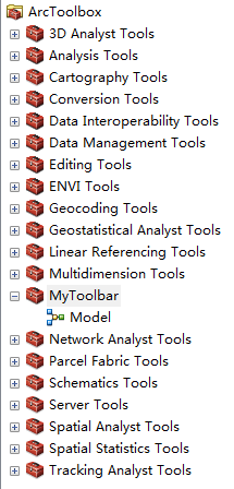
图1 新建模型
然后,添加工具到该模型中,搜索IDW,Slope,Reclassify到该模型中,然后进行连接及参数设置,IDW右键,Make Variable,From Parammeter,Input point features,即完成添加输入参数。双击Reclassify,在Reclassification中设置重分类的属性,如图2所示。
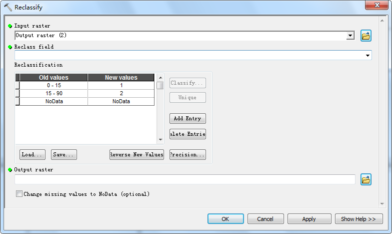
图2 Reclassify中Reclassification的设置
需要注意的事,在输入Old values时,”-”前后需添加空格,而且最后一行NoData也是要添加的,否则会出现如图3所示错误。
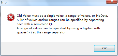
图3 输入Old values时未输入空格显示的错误提示
最后,在Input point features和Output raster(3)分别右键选择Model Parameter命令,右上角出现“p”即为设置成功。
至此,自定义建模完成,在ArcGIS中运行成功无误后便可进入下一步,调用自定义模型。
2.调用自定义模型
VS2010中,设计界面如图4所示。
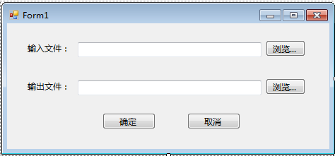 图4 设计界面图
引用命名空间:
ESRI.ArcGIS.AnalysisTools
ESRI.ArcGIS.Geoprocessor
ESRI.ArcGIS.System
ESRI.ArcGIS.Version
代码中加入:
using ESRI.ArcGIS.Geoprocessor;
using ESRI.ArcGIS.esriSystem;
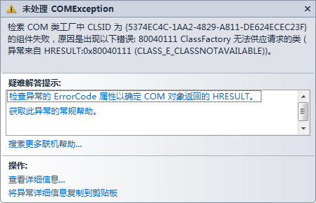
图5 错误一
当出现如图5所示错误时,解决办法如下:
 1     static class Program
 2     {
 3         /// <summary>
 4         /// 应用程序的主入口点。
 5         /// </summary>
 6         [STAThread]
 7         static void Main()
 8         {
 9             Application.EnableVisualStyles();
10             Application.SetCompatibleTextRenderingDefault(false);
11             ESRI.ArcGIS.RuntimeManager.Bind(ESRI.ArcGIS.ProductCode.EngineOrDesktop);
12             Application.Run(new Form1());
13         }
14     }
即在Program.cs中添加ESRI.ArcGIS.RuntimeManager.Bind(ESRI.ArcGIS.ProductCode.EngineOrDesktop);
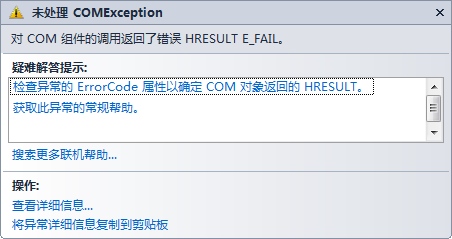
图6 错误二
解决办法为:Form1中添加License授权代码
1 IAoInitialize pAoInitialize = new AoInitializeClass();
2 esriLicenseStatus licenseStatus = esriLicenseStatus.esriLicenseUnavailable;
3 licenseStatus = pAoInitialize.Initialize(esriLicenseProductCode.esriLicenseProductCodeAdvanced);
4  pAoInitialize.CheckOutExtension(esriLicenseExtensionCode.esriLicenseExtensionCode3DAnalyst);
至此,整个应用程序运行成功!效果如图7所示。
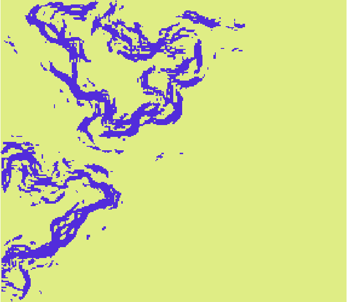
图7 运行结果图
最后,附上整个应用程序的代码:
 1 using System;
 2 using System.Collections.Generic;
 3 using System.ComponentModel;
 4 using System.Data;
 5 using System.Drawing;
 6 using System.Linq;
 7 using System.Text;
 8 using System.Windows.Forms;
 9
10 using ESRI.ArcGIS.Geoprocessor;
11 using ESRI.ArcGIS.esriSystem;
12
13 namespace CallModel
14 {
15     public partial class Form1 : Form
16     {
17         public Form1()
18         {
19             IAoInitialize pAoInitialize = new AoInitializeClass();
20             esriLicenseStatus licenseStatus = esriLicenseStatus.esriLicenseUnavailable;
21             licenseStatus = pAoInitialize.Initialize(esriLicenseProductCode.esriLicenseProductCodeAdvanced);
22             pAoInitialize.CheckOutExtension(esriLicenseExtensionCode.esriLicenseExtensionCode3DAnalyst);
23
24             InitializeComponent();
25         }
26
27         private void Form1_Load(object sender, EventArgs e)
28         {
29
30         }
31
32         private void button1_Click(object sender, EventArgs e)
33         {
34             OpenFileDialog openFileDialog = new OpenFileDialog();
35             openFileDialog.Title = "打开文件";
36             openFileDialog.Filter = "(shp文件)*.shp|*.shp";
37             if (openFileDialog.ShowDialog() == DialogResult.OK)
38             {
39                 textBox1.Text = openFileDialog.FileName;
40             }
41         }
42
43         private void button2_Click(object sender, EventArgs e)
44         {
45             SaveFileDialog saveDialog = new SaveFileDialog();
46             saveDialog.Title = "保存文件";
47             saveDialog.Filter = "(tif文件)*.tif|*.tif|(img文件)*.img|*.img";
48             if (saveDialog.ShowDialog() == DialogResult.OK)
49             {
50                 textBox2.Text = saveDialog.FileName;
51             }
52         }
53
54         private void button3_Click(object sender, EventArgs e)
55         {
56             Geoprocessor gp = new Geoprocessor();
57             gp.OverwriteOutput = true;
58
59             gp.AddToolbox(@"D:\Program Files\ArcGIS\Desktop10.1\ArcToolbox\Toolboxes\MyToolbar.tbx");
60             IVariantArray parameters = new VarArrayClass();
61             parameters.Add(textBox1.Text.ToString().Trim());
62             parameters.Add(textBox2.Text.ToString().Trim());
63             gp.Execute("Model", parameters, null);
64             MessageBox.Show("调用成功!", "提示");
65         }
66
67         private void button4_Click(object sender, EventArgs e)
68         {
69             this.Close();
70             //System.Environment.Exit(System.Environment.ExitCode);终止程序方式二
71             //Application.Exit();终止程序方式三
72         }
73     }
74 }