1、前言
1.1、环境准备:
- ArcGIS for Desktop 10.4.1(10.2.1以上版本即可)
- ArcGIS for Server 10.4.1 (10.2.1以上版本即可)
- PostgreSQL、Microsoft SQL Server、或 Oracle 设置企业级地理数据库。
1.2、发布具有同步能力的FeatureService服务
过程参考 数据制作篇:发布具有同步能力的FeatureService服务 一文。
转载请注明出处:http://www.cnblogs.com/gis-luq/p/5858048.html
2、demo实现过程
ArcGIS Runtime SDK 配置实现过程略:具体请参考:
基于Android Studio构建ArcGIS Android开发环境
基于Android Studio构建ArcGIS Android开发环境(离线部署)
2.1、Demo UI实现
activity_main.xml
<?xml version="1.0" encoding="utf-8"?>
<RelativeLayout xmlns:android="http://schemas.android.com/apk/res/android"
    xmlns:tools="http://schemas.android.com/tools"
    android:layout_width="match_parent"
    android:layout_height="match_parent"
    tools:context="com.example.downgdb.MainActivity">

    <!-- MapView -->
    <com.esri.android.map.MapView
        android:id="@+id/map"
        android:layout_width="fill_parent"
        android:layout_height="fill_parent"
        mapoptions.MapType="Topo"
        mapoptions.ZoomLevel="5"
        mapoptions.center="28.671298, 104.066404" />

    <LinearLayout
        android:orientation="horizontal"
        android:layout_width="match_parent"
        android:layout_height="wrap_content"
        android:padding="10dp"
        android:id="@+id/linearLayout"
        android:background="@color/primary_material_light">

        <EditText
            android:layout_width="match_parent"
            android:layout_height="match_parent"
            android:id="@+id/editTextGDBUrl"
            android:layout_alignParentTop="true"
            android:layout_alignParentRight="true"
            android:layout_alignParentEnd="true"
            android:layout_weight="1"
            android:text="http://192.168.1.212:6080/arcgis/rest/services/testdata/FeatureServer"
            android:inputType="textUri" />

        <Button
            android:layout_width="wrap_content"
            android:layout_height="wrap_content"
            android:text="数据下载"
            android:id="@+id/btnDownGDB" />
    </LinearLayout>


</RelativeLayout>
2.2、在Android清单文件AndroidManifest.xml中增加网络及存储访问权限
    <uses-permission android:name="android.permission.INTERNET" />
    <uses-permission android:name="android.permission.WRITE_EXTERNAL_STORAGE" />
2.3、实现离线地理数据库下载逻辑
基本思路:
- 设置.geodatabase文件存储路径
- 根据FeatureService服务获取FeatureServiceInfo服务参数信息
- 根据FeatureServiceInfo信息创建离线地理数据库文件、
- 从已经下载的本地Geodatabase文件中加载矢量数据
下载数据的核心功能类说明:
-
GeodatabaseSyncTask类,实现下载同步功能
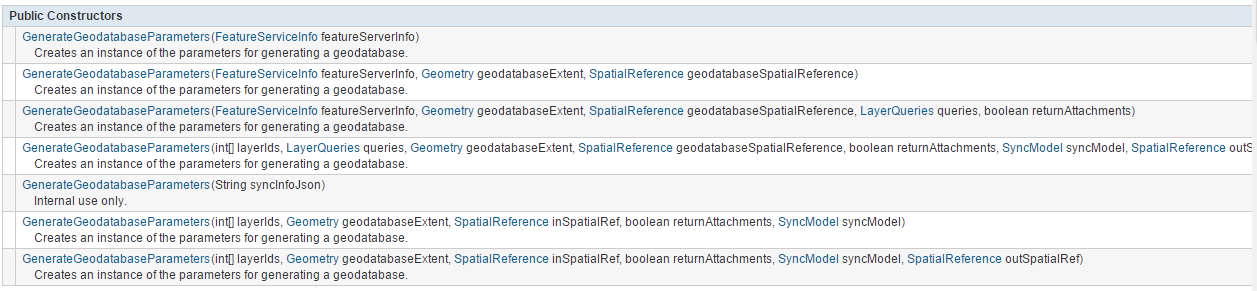
- GenerateGeodatabaseParameters,下载数据时所需的参数对象,该类构造函数一共有7个根据需要选择:
本次示例代码主要用到以下三个参数:
-
- featureServerInfo 服务参数信息
- geodatabaseExtent 地图下载区域范围
- geodatabaseSpatialReference 地图空间参考
- CallbackListener<Geodatabase>,完成GDB数据库下载的回调函数类,在该回调中我们只可以执行一些操作,如示例里在回调中删除了在线的服务图层,加载离线的数据图层到地图上进行显示。通过Geodatabase本地数据库可以获取要素图层列表List<GdbFeatureTable>对象,通过newFeatureLayer(gdbFeatureTable)来创建一个离线要素图层进行要素显示。
- GeodatabaseStatusCallback,本地数据库回调状态类,在数据下载过程中会有很多状态改变,各种状态改变时都会走这个类的回调函数。
- GeodatabaseTask.generateGeodatabase,通过该方法生成离线数据库和相应的要素表,方法需要传递上面介绍的三个参数和一个数据库存储的路径。
完整代码示例:
package com.example.downgdb;

import android.app.Activity;
import android.app.ProgressDialog;
import android.content.Context;
import android.os.Environment;
import android.support.v7.app.AppCompatActivity;
import android.os.Bundle;
import android.util.Log;
import android.view.View;
import android.view.WindowManager;
import android.widget.Button;
import android.widget.EditText;

import com.esri.android.map.FeatureLayer;
import com.esri.android.map.MapView;
import com.esri.core.ags.FeatureServiceInfo;
import com.esri.core.geodatabase.Geodatabase;
import com.esri.core.geodatabase.GeodatabaseFeatureTable;
import com.esri.core.map.CallbackListener;
import com.esri.core.tasks.geodatabase.GenerateGeodatabaseParameters;
import com.esri.core.tasks.geodatabase.GeodatabaseStatusCallback;
import com.esri.core.tasks.geodatabase.GeodatabaseStatusInfo;
import com.esri.core.tasks.geodatabase.GeodatabaseSyncTask;

import java.io.File;
import java.io.FileNotFoundException;
import java.util.ArrayList;

public class MainActivity extends AppCompatActivity {

    protected static final String TAG = "downGDB";
    private Context context;

    private MapView mMapView;//地图容器

    private EditText editTextDownGDBUrl;//GDB地址
    private Button btnDownGDB;//下载GDB

    private static String onlineFeatureLayerUrl;//在线FeatureLayer地址
    private static String localGdbFilePath;//离线GDB地址

    private GeodatabaseSyncTask gdbSyncTask;//离线地理数据库下载Task
    private ProgressDialog mProgressDialog;//状态框

    @Override
    protected void onCreate(Bundle savedInstanceState) {
        super.onCreate(savedInstanceState);
        setContentView(R.layout.activity_main);

        context = this;
        // 默认软键盘不弹出
        getWindow().setSoftInputMode( WindowManager.LayoutParams.SOFT_INPUT_STATE_HIDDEN);

        this.mMapView = (MapView)findViewById(R.id.map);
        this.editTextDownGDBUrl = (EditText)findViewById(R.id.editTextGDBUrl);
        //获取并设置在线服务地址
        this.onlineFeatureLayerUrl = this.editTextDownGDBUrl.getText().toString();

        mProgressDialog = new ProgressDialog(context);
        //设置点击进度对话框外的区域对话框不消失
        mProgressDialog.setCanceledOnTouchOutside(false);
        mProgressDialog.setTitle("正在创建离线地理数据库副本");

        //绑定按钮设置下载事件
        btnDownGDB = (Button)this.findViewById(R.id.btnDownGDB);
        btnDownGDB.setOnClickListener(new View.OnClickListener() {
            @Override
            public void onClick(View v) {
                downloadData(onlineFeatureLayerUrl);//下载离线数据
            }
        });

    }

    /**
     * Geodatabase文件存储路径
     */
    static String createGeodatabaseFilePath() {
        return Environment.getExternalStorageDirectory().getAbsolutePath() + File.separator + "/RuntimeOfflineEdit"
                + File.separator + "demo.geodatabase";
    }

    /**
     * 下载离线地理数据库
     * @param url FeatureService服务地址
     * 例如:http://192.168.1.212:6080/arcgis/rest/services/testdata/FeatureServer
     * 支持ArcGIS for Server 10.2.1以上版本,必须开启FeatureServer要素同步功能
     */
    private void downloadData(String url) {
        Log.i(TAG, "Create GeoDatabase");
        // create a dialog to update user on progress
        mProgressDialog.show();

        gdbSyncTask = new GeodatabaseSyncTask(url, null);
        gdbSyncTask.fetchFeatureServiceInfo(new CallbackListener<FeatureServiceInfo>() {

            @Override
            public void onError(Throwable arg0) {
                Log.e(TAG, "获取FeatureServiceInfo失败");
            }

            @Override
            public void onCallback(FeatureServiceInfo fsInfo) {
                if (fsInfo.isSyncEnabled()) {
                    createGeodatabase(fsInfo);
                }
            }
        });
    }

    /**
     * 根据FeatureServiceInfo信息创建离线地理数据库文件
     * @param featureServerInfo 服务参数信息
     */
    private void createGeodatabase(FeatureServiceInfo featureServerInfo) {
        // 生成一个geodatabase设置参数
        GenerateGeodatabaseParameters params = new GenerateGeodatabaseParameters(
                featureServerInfo, mMapView.getMaxExtent(), mMapView.getSpatialReference());

        // 下载结果回调函数
        CallbackListener<String> gdbResponseCallback = new CallbackListener<String>() {
            @Override
            public void onError(final Throwable e) {
                Log.e(TAG, "创建geodatabase失败");
                mProgressDialog.dismiss();
            }

            @Override
            public void onCallback(String path) {
                Log.i(TAG, "Geodatabase 路径: " + path);
                mProgressDialog.dismiss();
                loadGeodatabase(path);
            }
        };

        // 下载状态回调函数
        GeodatabaseStatusCallback statusCallback = new GeodatabaseStatusCallback() {
            @Override
            public void statusUpdated(final GeodatabaseStatusInfo status) {
                final String progress = status.getStatus().toString();
                //在UI线程更新下载状态
                ((Activity)context).runOnUiThread(new Runnable(){
                    @Override
                    public void run() {
                        mProgressDialog.setMessage("数据下载中,请稍后……");
                    }
                });

            }
        };

        //设置离线地理数据库存储路径
        localGdbFilePath = createGeodatabaseFilePath();

        //执行下载Geodatabase数据库
        gdbSyncTask.generateGeodatabase(params, localGdbFilePath, false, statusCallback, gdbResponseCallback);
    }

    /**
     * 加载离线地理数据库
     * @param path .geodatabse文件路径
     */
    private void loadGeodatabase(String path) {
        // 创建一个geodatabase数据库
        Geodatabase localGdb = null;
        try {
            localGdb = new Geodatabase(path);
        } catch (FileNotFoundException e) {
            e.printStackTrace();
        }

        // 添加FeatureLayer到MapView中
        if (localGdb != null) {
            for (GeodatabaseFeatureTable gdbFeatureTable : localGdb.getGeodatabaseTables()) {
                if (gdbFeatureTable.hasGeometry()){
                    mMapView.addLayer(new FeatureLayer(gdbFeatureTable));
                }
            }
        }
    }

}
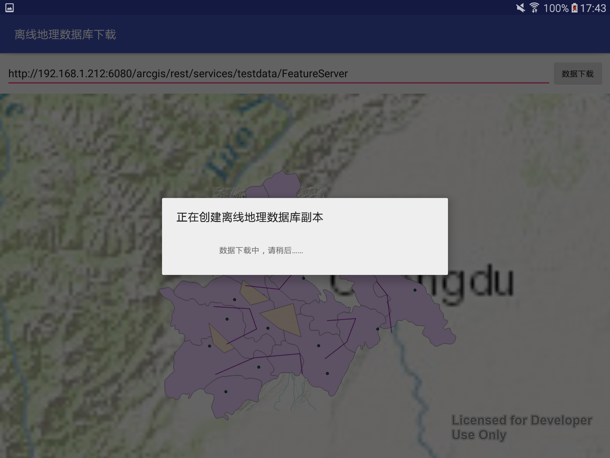
3、Demo运行结果
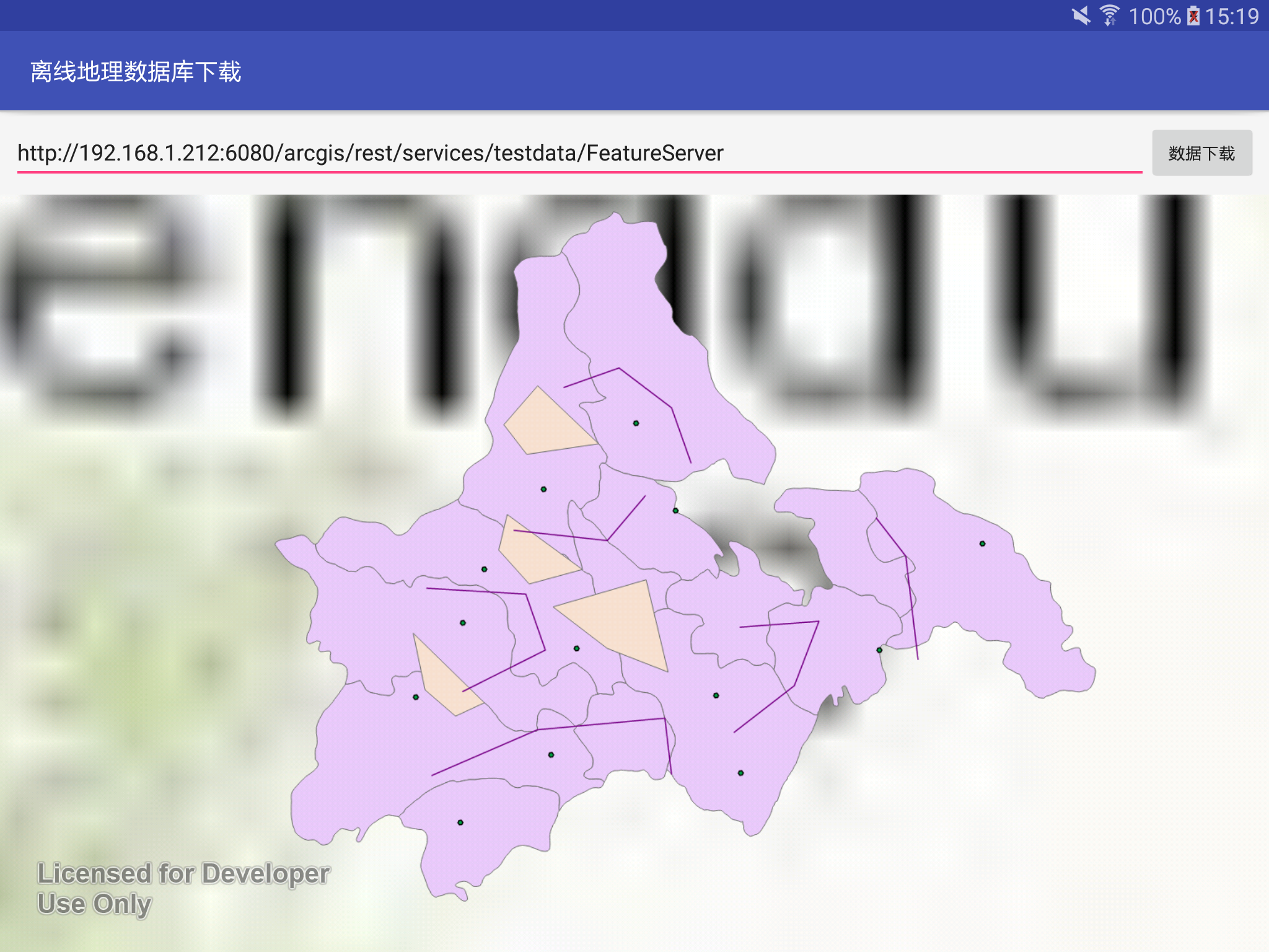
源代码托管地址:http://git.oschina.net/gis-luq/RuntimeOfflineEdit
4、参考资料
http://blog.csdn.net/arcgis_all/article/details/20442663
相关内容列表
《ArcGIS Runtime SDK for Android开发笔记》——离在线一体化技术:概述
《ArcGIS Runtime SDK for Android开发笔记》——离在线一体化技术:离线矢量数据下载
《ArcGIS Runtime SDK for Android开发笔记》——离在线一体化技术:离线矢量数据编辑
《ArcGIS Runtime SDK for Android开发笔记》——离在线一体化技术:离线矢量数据同步
《ArcGIS Runtime SDK for Android开发笔记》——数据制作篇:发布具有同步能力的FeatureService服务