地图应用经常会涉及到线路的绘制问题,ios下可以使用MKMapView进行地图开发,使用
MKOverlayView进行线路的绘制。
使用MKMapView添加MKMap.framework 和CoreLocation.framework并导入
MapKit.h头文件。
新建一个基于视图的工程,修改头文件:
1 #import <UIKit/UIKit.h>
2 #import <MapKit/MapKit.h>
3 #import "CloMKAnnotation.h"
4 @interface CloViewController : UIViewController<CLLocationManagerDelegate, MKMapViewDelegate, UIActionSheetDelegate>{
5     MKMapView *cloMapView;
6     MKPolyline *routeLine;
7 }
8
9 @property (nonatomic, strong)  NSMutableArray *locations;
修改实现代码,在.m中添加如下代码:
  1 #import "CloViewController.h"
  2
  3 @interface CloViewController ()
  4
  5 @end
  6
  7 @implementation CloViewController
  8 @synthesize locations;
  9
 10 - (void)viewDidLoad
 11 {
 12     [super viewDidLoad];
 13     // Do any additional setup after loading the view, typically from a nib.
 14     cloMapView = [[MKMapView alloc] initWithFrame:[self.view bounds]];
 15     [cloMapView setMapType:MKMapTypeHybrid];  //设置地图类型 地图/卫星/两者结合
 16     [cloMapView setShowsUserLocation:YES];      //显示当前位置
 17     [cloMapView setDelegate:self];
 18
 19     CLLocationManager *locationManager = [[CLLocationManager alloc] init];
 20     //设置CLLocationManager实例委托和精度
 21     [locationManager setDelegate:self];
 22     [locationManager setDesiredAccuracy:kCLLocationAccuracyBest];
 23     //设置距离筛选器,表示至少移动100米才通知委托更新
 24     [locationManager setDistanceFilter:100.f];
 25     //启动更新请求
 26 //    [locationManager startUpdatingLocation];
 27
 28     locations = [[NSMutableArray alloc] init];
 29     float latitude = 39.8127;    //维度
 30     float longitude = 116.2967;  //经度
 31     for (int i = 0; i < 10; i++) {
 32
 33         [locations addObject:[NSString stringWithFormat:@"%f,%f", latitude + 0.01*i, longitude + 0.01*i]];
 34 //            NSLog(@"locations:%i",locations.count);
 35     }
 36
 37     //地图初始
 38     CLLocationCoordinate2D coords;
 39     coords.latitude = 39.9127;
 40     coords.longitude = 116.3967;
 41     float zoomlevel = 0.22;
 42     MKCoordinateRegion region = MKCoordinateRegionMake(coords, MKCoordinateSpanMake(zoomlevel, zoomlevel));
 43     [cloMapView setRegion:[cloMapView regionThatFits:region] animated:YES];
 44
 45     [cloMapView addOverlay:[self makePolylineWithLocations:locations]];
 46     [self.view addSubview:cloMapView];
 47
 48 }
 49
 50 - (void)viewDidUnload
 51 {
 52     [super viewDidUnload];
 53     // Release any retained subviews of the main view.
 54     cloMapView = nil;
 55 }
 56
 57 - (void)dealloc{
 58     [cloMapView release];
 59     [super dealloc];
 60 }
 61
 62 - (BOOL)shouldAutorotateToInterfaceOrientation:(UIInterfaceOrientation)interfaceOrientation
 63 {
 64     return (interfaceOrientation != UIInterfaceOrientationPortraitUpsideDown);
 65 }
 66
 67
 68 //显示菜单选项
 69 - (void)showActionSheet :(id)sender{
 70     UIActionSheet * actionSheet = [[UIActionSheet alloc] initWithTitle:nil
 71                                                               delegate:self
 72                                                      cancelButtonTitle:@"取消"
 73                                                 destructiveButtonTitle:@"添加足迹"
 74                                                      otherButtonTitles:@"分享",@"详细",@"删除", nil];
 75     [actionSheet setDelegate:self];
 76     [actionSheet showInView:self.view];
 77     [actionSheet release];
 78 }
 79
 80 //根据坐标点生成线路
 81 - (MKPolyline *)makePolylineWithLocations:(NSMutableArray *)newLocations{
 82     MKMapPoint *pointArray = malloc(sizeof(CLLocationCoordinate2D)* newLocations.count);
 83     for(int i = 0; i < newLocations.count; i++)
 84     {
 85         // break the string down even further to latitude and longitude fields.
 86         NSString* currentPointString = [newLocations objectAtIndex:i];
 87         NSArray* latLonArr = [currentPointString componentsSeparatedByCharactersInSet:[NSCharacterSet characterSetWithCharactersInString:@","]];
 88         CLLocationDegrees latitude  = [[latLonArr objectAtIndex:0] doubleValue];
 89         //        NSLog(@"latitude-> %f", latitude);
 90         CLLocationDegrees longitude = [[latLonArr objectAtIndex:1] doubleValue];
 91         CLLocationCoordinate2D coordinate = CLLocationCoordinate2DMake(latitude, longitude);
 92         //        NSLog(@"point-> %f", point.x);
 93
 94         if (i == 0 || i == locations.count - 1) {//这里只添加起点和终点作为测试
 95             CloMKAnnotation *ann = [[CloMKAnnotation alloc] init];
 96             [ann setCoordinate:coordinate];
 97             [ann setTitle:[NSString stringWithFormat:@"纬度:%f", latitude]];
 98             [ann setSubtitle:[NSString stringWithFormat:@"经度:%f", longitude]];
 99             [cloMapView addAnnotation:ann];
100         }
101         pointArray[i] = MKMapPointForCoordinate(coordinate);
102     }
103
104     routeLine = [MKPolyline polylineWithPoints:pointArray count:newLocations.count];
105     free(pointArray);
106     return routeLine;
107 }
108 #pragma mark-
109 #pragma CLLocationManager delegate method
110 //位置变化后会调用
111 - (void)locationManager:(CLLocationManager *)manager didUpdateToLocation:(CLLocation *)newLocation fromLocation:(CLLocation *)oldLocation{
112     //可在此处更新用户位置信息
113 //    cloMapView.userLocation
114     NSLog(@"oldLocation:%@", [oldLocation description]);
115     NSLog(@"newLocation:%@", [newLocation description]);
116     NSLog(@"distance:%@", [newLocation distanceFromLocation:oldLocation]);
117     //位置变化添加新位置点
118     [locations addObject:[NSString stringWithFormat:@"%f,%f", newLocation.coordinate.latitude, newLocation.coordinate.longitude]];
119     //删除进线路,更新新轨迹
120     [cloMapView removeOverlay:routeLine];
121     [cloMapView addOverlay:[self makePolylineWithLocations:locations]];
122
123 }
124
125 #pragma MKMapView delegate method
126 //添加坐标点大头针
127 - (MKAnnotationView *)mapView:(MKMapView *)mapView viewForAnnotation:(id<MKAnnotation>)annotation{
128     if (![annotation isKindOfClass:[CloMKAnnotation class]]) {
129         return nil;
130     }
131     static NSString *identifier = @"Annotation";
132     MKPinAnnotationView *pinAnnotationView = (MKPinAnnotationView *)[mapView dequeueReusableAnnotationViewWithIdentifier:identifier];
133     if (pinAnnotationView == nil) {
134         pinAnnotationView = [[[MKPinAnnotationView alloc] initWithAnnotation:annotation reuseIdentifier:identifier] autorelease];
135     }
136     pinAnnotationView.animatesDrop = YES;
137     pinAnnotationView.canShowCallout = YES;
138     pinAnnotationView.draggable = YES;
139     UIButton *detailBtn = [UIButton buttonWithType:UIButtonTypeDetailDisclosure];
140     [detailBtn addTarget:self action:@selector(showActionSheet:) forControlEvents:UIControlEventTouchUpInside];
141     pinAnnotationView.rightCalloutAccessoryView = detailBtn;
142
143     return pinAnnotationView;
144 }
145
146 - (void)mapView:(MKMapView *)mapView annotationView:(MKAnnotationView *)view didChangeDragState:(MKAnnotationViewDragState)newState fromOldState:(MKAnnotationViewDragState)oldState{
147
148 }
149
150 //画线
151 - (MKOverlayView *)mapView:(MKMapView *)mapView viewForOverlay:(id<MKOverlay>)overlay{
152     NSLog(@"return overLayView...");
153     if ([overlay isKindOfClass:[MKPolyline class]]) {
154         MKPolylineView *routeLineView = [[[MKPolylineView alloc] initWithPolyline:routeLine] autorelease];
155         routeLineView.strokeColor = [UIColor blueColor];
156         routeLineView.lineWidth = 3;
157         return routeLineView;
158     }
159     return nil;
160 }
161
162 @end
这里主要是为了测试,初始时 locations坐标点自定义的,实际中是根据用户的位置动态生成的一系列坐标点。具体可在下面方法中实现
1 - (void)locationManager:(CLLocationManager *)manager didUpdateToLocation:(CLLocation *)newLocation fromLocation:(CLLocation *)oldLocation
另外用户的实时位置可用
1 cloMapView.userLocation = newLocation进行设置,然后显示在地图上。
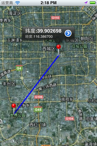
运行效果