<!--pages/API/LocationAndMap/index.wxml-->
<view class="box">
  <view class='title'>位置和地图</view>
  <view class='style01'>
    <map id="myMap" latitude="{{latitude}}" longitude="{{longitude}}" markers="{{markers}}" show-location></map>
  </view>
  <view class='btnLayout'>
    <button bindtap="chooseLocation" type="primary">选择位置</button>
    <button bindtap="openLocation" type="primary">打开位置</button>
  </view>
</view>
<view class='style01'>
<map id="myMap" latitude="{{latitude}}" longitude="{{longitude}}" markers="{{markers}}" show-location></map>
</view>
id标识地图 ,latitude、longitude经纬度属性,js文件中传过来的 markers中心位置的标记,数据绑定js文件进行的设置 ,show-location显示位置,运行程序的时候右上角出现箭头的位置标识
/* pages/API/LocationAndMap/index.wxss */

map {
  margin: 10px 0px;
  width: 100%;
  height: 320px;
}

.btnLayout {/*行布局,水平居中,自动根据文字多少决定按钮长度 */
  display: flex;
  flex-direction: row;
  justify-content: center;
}
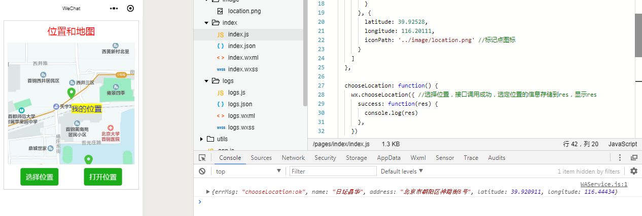
// pages/API/LocationAndMap/index.js

Page({
  data: {//初始的值
    latitude: 39.93111, //纬度
    longitude: 116.199167, //经度
    markers: [
      {
        id: 1,
        latitude: 39.93111,
        longitude: 116.199167,
        iconPath: '../image/location.png', //标记点图标
        label: { //标记点标签
          content: '我的位置', //标记点文本
          color: '#0000FF', //标记点文本颜色
          bgColor: '#FFFF00', //标记点文本背景颜色
          fontSize: 20
        }
      }, {
        latitude: 39.92528,
        longitude: 116.20111,
        iconPath: '../image/location.png' //标记点图标
      }
    ]
  },

  chooseLocation: function() {
    wx.chooseLocation({ //选择位置,接口调用成功,选定位置的信息存储到res,显示res
      success: function(res) {
        console.log(res)
      },
    })
  },

  openLocation: function() {
    wx.getLocation({ //获取位置,获取位置的类型默认wgs84,这里采用gcj02(国家测绘局制定的一个地理坐标系统),
      type: 'gcj02',
      success: function(res) {//获取位置成功,位置存储到res里
        wx.openLocation({ //打开获得的位置
          latitude: res.latitude,
          longitude: res.longitude,
          scale: 28,//缩放比例28
        })
      },
    })
  }
})
map地图组件

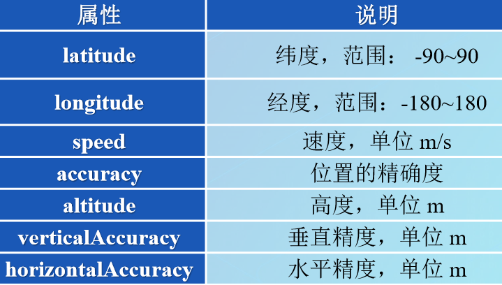
Markers对象数组元素的属性

API函数wx.getLocation(Object object)
wx.getLocation(Object object)用于获取当前的地理位置和速度, 调用前需要用户在app.json 文件中授权 scope.userLocation。其参数属性包括success 等回调函数。
success 回调函数的参数属性
API函数wx.chooseLocation(Object object)
wx.chooseLocation(Object object)用于打开地图选择位置,其参数属性包括回调函数:success、fail和complete。
API函数wx.openLocation(Object object)
wx.openLocation(Object object)使用微信内置地图查看位置,其参数属性如下:
