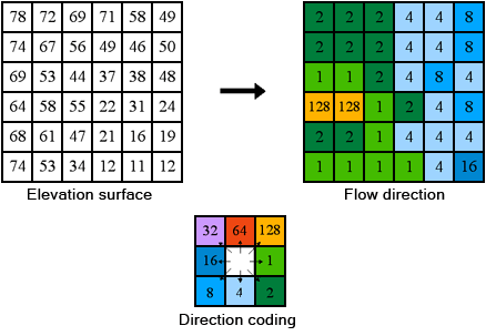
ArcGIS采用D8算法计算水流方向(9.3.1后新增),输入数据应首先完成了洼地填充处理:
One of the keys to deriving hydrologic characteristics about a surface is the ability to determine the direction of flow from every cell in the raster. This is done with the Flow Direction function.
This function takes a surface as input and outputs a raster showing the direction of flow out of each cell. If the output drop raster option is chosen, an output raster is created showing a ratio of the maximum change in elevation from each cell along the direction of flow to the path length between centers of cells and is expressed in percentages. If the force all edge cells to flow outward option is chosen, all cells at the edge of the surface raster will flow outward from the surface raster.

There are eight valid output directions relating to the eight adjacent cells into which flow could travel. This approach is commonly referred to as an eight direction (D8) flow model and follows an approach presented in Jensen and Domingue (1988).
The direction of flow is determined by finding the direction of steepest descent, or maximum drop, from each cell. This is calculated as
maximum drop = change in z-value / distance
The distance is determined between cell centers. Therefore if the cell size is one, the distance between two orthogonal cells is one and the distance between two diagonal cells is 1.414216, the square root of two. If the maximum descent to several cells is the same, the neighborhood is enlarged until the steepest descent is found.
When a direction of steepest descent is found, the output cell is coded with the value representing that direction.
If all neighbors are higher than the processing cell, the processing cell is a sink and has an undefined flow direction. Cells with undefined flow direction can be flagged as sinks using the Sink function. To obtain an accurate representation of flow direction across a surface, the sinks should be filled.